You are here: Home > Network List > LD - Lamont-Doherty Cooperative Seismographic Network Stations List
> Station GEDE Greenville, DE, USA > Earthquake Result Viewer
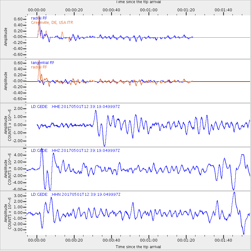
GEDE Greenville, DE, USA - Earthquake Result Viewer
*The percent match for this event was below the threshold and hence no stack was calculated.
| Earthquake location: |
Southeastern Alaska |
| Earthquake latitude/longitude: |
59.9/-136.6 |
| Earthquake time(UTC): |
2017/05/01 (121) 12:31:53 GMT |
| Earthquake Depth: |
0.1 km |
| Earthquake Magnitude: |
6.5 Ml |
| Earthquake Catalog/Contributor: |
NEIC PDE/ak |
|
| Network: |
LD Lamont-Doherty Cooperative Seismographic Network |
| Station: |
GEDE Greenville, DE, USA |
| Lat/Lon: |
39.81 N/75.64 W |
| Elevation: |
105 m |
|
| Distance: |
42.3 deg |
| Az: |
90.119 deg |
| Baz: |
319.079 deg |
| Ray Param: |
$rayparam |
*The percent match for this event was below the threshold and hence was not used in the summary stack. |
|
| Radial Match: |
88.62747 % |
| Radial Bump: |
323 |
| Transverse Match: |
71.31703 % |
| Transverse Bump: |
400 |
| SOD ConfigId: |
11737051 |
| Insert Time: |
2019-04-27 06:21:47.070 +0000 |
| GWidth: |
2.5 |
| Max Bumps: |
400 |
| Tol: |
0.001 |
|
Signal To Noise
| Channel | StoN | STA | LTA |
| LD:GEDE: :HHZ:20170501T12:39:19.049997Z | 18.552649 | 3.2692283E-6 | 1.7621356E-7 |
| LD:GEDE: :HHN:20170501T12:39:19.049997Z | 8.780922 | 1.2107338E-6 | 1.3788232E-7 |
| LD:GEDE: :HHE:20170501T12:39:19.049997Z | 6.6305637 | 8.923509E-7 | 1.3458146E-7 |
| Arrivals |
| Ps | |
| PpPs | |
| PsPs/PpSs | |


