You are here: Home > Network List > TA - USArray Transportable Network (new EarthScope stations) Stations List
> Station Z16A Peralta Trail, Apache Junction, AZ, USA > Earthquake Result Viewer
Z16A Peralta Trail, Apache Junction, AZ, USA - Earthquake Result Viewer
| Earthquake location: |
Southeast Of Loyalty Islands |
| Earthquake latitude/longitude: |
-21.2/169.4 |
| Earthquake time(UTC): |
2007/09/28 (271) 01:01:48 GMT |
| Earthquake Depth: |
10 km |
| Earthquake Magnitude: |
5.8 MB, 6.4 MS, 6.3 MW, 6.2 MW |
| Earthquake Catalog/Contributor: |
WHDF/NEIC |
|
| Network: |
TA USArray Transportable Network (new EarthScope stations) |
| Station: |
Z16A Peralta Trail, Apache Junction, AZ, USA |
| Lat/Lon: |
33.34 N/111.43 W |
| Elevation: |
537 m |
|
| Distance: |
92.9 deg |
| Az: |
55.422 deg |
| Baz: |
246.605 deg |
| Ray Param: |
0.04136807 |
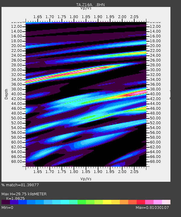
| Estimated Moho Depth: |
29.75 km |
| Estimated Crust Vp/Vs: |
1.86 |
| Assumed Crust Vp: |
6.276 km/s |
| Estimated Crust Vs: |
3.37 km/s |
| Estimated Crust Poisson's Ratio: |
0.30 |
|
| Radial Match: |
81.39877 % |
| Radial Bump: |
400 |
| Transverse Match: |
66.86201 % |
| Transverse Bump: |
400 |
| SOD ConfigId: |
2564 |
| Insert Time: |
2010-03-05 23:30:01.451 +0000 |
| GWidth: |
2.5 |
| Max Bumps: |
400 |
| Tol: |
0.001 |
|

Signal To Noise
| Channel | StoN | STA | LTA |
| TA:Z16A: :BHN:20070928T01:14:30.250024Z | 1.052692 | 9.10494E-8 | 8.649196E-8 |
| TA:Z16A: :BHE:20070928T01:14:30.250024Z | 2.6149967 | 2.2082187E-7 | 8.444442E-8 |
| TA:Z16A: :BHZ:20070928T01:14:30.250024Z | 4.0664973 | 4.1971978E-7 | 1.0321407E-7 |
| Arrivals |
| Ps | 4.2 SECOND |
| PpPs | 13 SECOND |
| PsPs/PpSs | 17 SECOND |


