You are here: Home > Network List > TA - USArray Transportable Network (new EarthScope stations) Stations List
> Station Z16A Peralta Trail, Apache Junction, AZ, USA > Earthquake Result Viewer
Z16A Peralta Trail, Apache Junction, AZ, USA - Earthquake Result Viewer
| Earthquake location: |
Andreanof Islands, Aleutian Is. |
| Earthquake latitude/longitude: |
51.3/-180.0 |
| Earthquake time(UTC): |
2007/08/02 (214) 03:21:42 GMT |
| Earthquake Depth: |
21 km |
| Earthquake Magnitude: |
6.3 MB, 6.6 MS, 6.7 MW, 6.6 MW |
| Earthquake Catalog/Contributor: |
WHDF/NEIC |
|
| Network: |
TA USArray Transportable Network (new EarthScope stations) |
| Station: |
Z16A Peralta Trail, Apache Junction, AZ, USA |
| Lat/Lon: |
33.34 N/111.43 W |
| Elevation: |
537 m |
|
| Distance: |
51.8 deg |
| Az: |
82.323 deg |
| Baz: |
312.001 deg |
| Ray Param: |
0.06713042 |
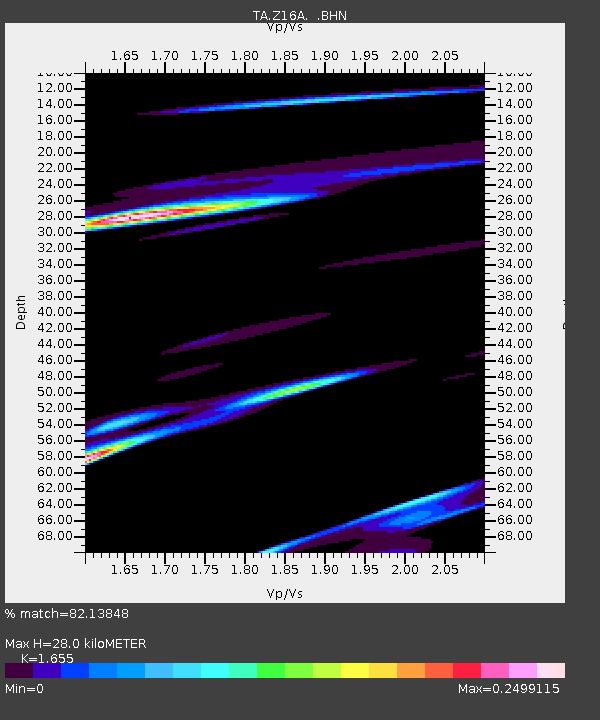
| Estimated Moho Depth: |
28.0 km |
| Estimated Crust Vp/Vs: |
1.65 |
| Assumed Crust Vp: |
6.276 km/s |
| Estimated Crust Vs: |
3.792 km/s |
| Estimated Crust Poisson's Ratio: |
0.21 |
|
| Radial Match: |
82.13848 % |
| Radial Bump: |
400 |
| Transverse Match: |
74.947235 % |
| Transverse Bump: |
400 |
| SOD ConfigId: |
2564 |
| Insert Time: |
2010-03-05 23:30:15.238 +0000 |
| GWidth: |
2.5 |
| Max Bumps: |
400 |
| Tol: |
0.001 |
|
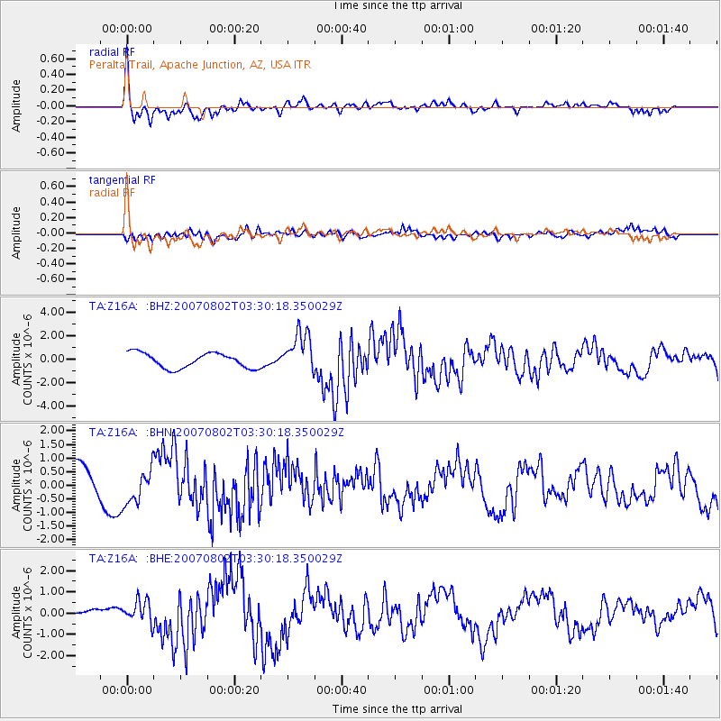
Signal To Noise
| Channel | StoN | STA | LTA |
| TA:Z16A: :BHN:20070802T03:30:18.350029Z | 0.9359894 | 6.685972E-7 | 7.143213E-7 |
| TA:Z16A: :BHE:20070802T03:30:18.350029Z | 1.8359516 | 5.25659E-7 | 2.8631422E-7 |
| TA:Z16A: :BHZ:20070802T03:30:18.350029Z | 2.7992384 | 1.7883809E-6 | 6.388812E-7 |
| Arrivals |
| Ps | 3.1 SECOND |
| PpPs | 11 SECOND |
| PsPs/PpSs | 14 SECOND |


