You are here: Home > Network List > TA - USArray Transportable Network (new EarthScope stations) Stations List
> Station Z16A Peralta Trail, Apache Junction, AZ, USA > Earthquake Result Viewer
Z16A Peralta Trail, Apache Junction, AZ, USA - Earthquake Result Viewer

| Earthquake location: |
Near West Coast Of Honshu, Japan |
| Earthquake latitude/longitude: |
37.5/138.5 |
| Earthquake time(UTC): |
2007/07/16 (197) 06:37:40 GMT |
| Earthquake Depth: |
15 km |
| Earthquake Magnitude: |
5.7 MB, 5.1 MS, 5.7 MW, 5.6 MW |
| Earthquake Catalog/Contributor: |
WHDF/NEIC |
|
| Network: |
TA USArray Transportable Network (new EarthScope stations) |
| Station: |
Z16A Peralta Trail, Apache Junction, AZ, USA |
| Lat/Lon: |
33.34 N/111.43 W |
| Elevation: |
537 m |
|
| Distance: |
84.1 deg |
| Az: |
52.211 deg |
| Baz: |
311.339 deg |
| Ray Param: |
0.04570988 |
| Estimated Moho Depth: |
28.0 km |
| Estimated Crust Vp/Vs: |
1.80 |
| Assumed Crust Vp: |
6.276 km/s |
| Estimated Crust Vs: |
3.487 km/s |
| Estimated Crust Poisson's Ratio: |
0.28 |
|
| Radial Match: |
81.77345 % |
| Radial Bump: |
400 |
| Transverse Match: |
74.93755 % |
| Transverse Bump: |
400 |
| SOD ConfigId: |
2564 |
| Insert Time: |
2010-03-05 23:30:26.781 +0000 |
| GWidth: |
2.5 |
| Max Bumps: |
400 |
| Tol: |
0.001 |
|
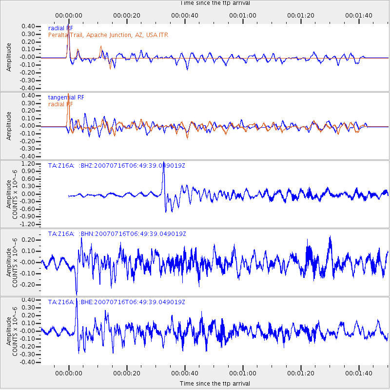
Signal To Noise
| Channel | StoN | STA | LTA |
| TA:Z16A: :BHN:20070716T06:49:39.049019Z | 2.5619514 | 1.0771061E-7 | 4.2042412E-8 |
| TA:Z16A: :BHE:20070716T06:49:39.049019Z | 4.6963196 | 1.4273445E-7 | 3.039283E-8 |
| TA:Z16A: :BHZ:20070716T06:49:39.049019Z | 9.08985 | 4.228911E-7 | 4.6523443E-8 |
| Arrivals |
| Ps | 3.7 SECOND |
| PpPs | 12 SECOND |
| PsPs/PpSs | 16 SECOND |


