You are here: Home > Network List > II - Global Seismograph Network (GSN - IRIS/IDA) Stations List
> Station WRAB Tennant Creek, NT, Australia > Earthquake Result Viewer
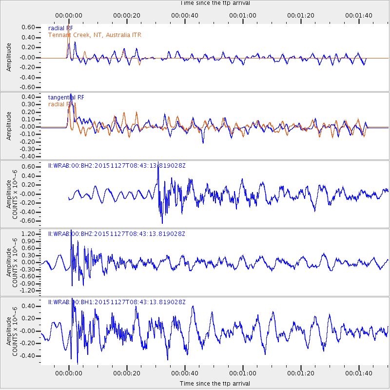
WRAB Tennant Creek, NT, Australia - Earthquake Result Viewer
*The percent match for this event was below the threshold and hence no stack was calculated.
| Earthquake location: |
Myanmar |
| Earthquake latitude/longitude: |
22.5/94.8 |
| Earthquake time(UTC): |
2015/11/27 (331) 08:33:59 GMT |
| Earthquake Depth: |
22 km |
| Earthquake Magnitude: |
5.5 MB |
| Earthquake Catalog/Contributor: |
NEIC PDE/NEIC COMCAT |
|
| Network: |
II Global Seismograph Network (GSN - IRIS/IDA) |
| Station: |
WRAB Tennant Creek, NT, Australia |
| Lat/Lon: |
19.93 S/134.36 E |
| Elevation: |
366 m |
|
| Distance: |
57.2 deg |
| Az: |
134.546 deg |
| Baz: |
315.528 deg |
| Ray Param: |
$rayparam |
*The percent match for this event was below the threshold and hence was not used in the summary stack. |
|
| Radial Match: |
40.552853 % |
| Radial Bump: |
400 |
| Transverse Match: |
59.693832 % |
| Transverse Bump: |
400 |
| SOD ConfigId: |
1259291 |
| Insert Time: |
2015-12-11 09:13:59.546 +0000 |
| GWidth: |
2.5 |
| Max Bumps: |
400 |
| Tol: |
0.001 |
|
Signal To Noise
| Channel | StoN | STA | LTA |
| II:WRAB:00:BHZ:20151127T08:43:13.819028Z | 3.0408895 | 4.772264E-7 | 1.5693645E-7 |
| II:WRAB:00:BH1:20151127T08:43:13.819028Z | 1.6557528 | 2.5300196E-7 | 1.5280179E-7 |
| II:WRAB:00:BH2:20151127T08:43:13.819028Z | 3.4275303 | 2.8814247E-7 | 8.406708E-8 |
| Arrivals |
| Ps | |
| PpPs | |
| PsPs/PpSs | |


