You are here: Home > Network List > TA - USArray Transportable Network (new EarthScope stations) Stations List
> Station Z16A Peralta Trail, Apache Junction, AZ, USA > Earthquake Result Viewer
Z16A Peralta Trail, Apache Junction, AZ, USA - Earthquake Result Viewer
| Earthquake location: |
Kermadec Islands, New Zealand |
| Earthquake latitude/longitude: |
-30.7/-178.2 |
| Earthquake time(UTC): |
2007/05/17 (137) 19:29:10 GMT |
| Earthquake Depth: |
41 km |
| Earthquake Magnitude: |
5.5 MB, 5.6 MS, 6.0 MW, 5.9 MW |
| Earthquake Catalog/Contributor: |
WHDF/NEIC |
|
| Network: |
TA USArray Transportable Network (new EarthScope stations) |
| Station: |
Z16A Peralta Trail, Apache Junction, AZ, USA |
| Lat/Lon: |
33.34 N/111.43 W |
| Elevation: |
537 m |
|
| Distance: |
89.6 deg |
| Az: |
50.29 deg |
| Baz: |
232.364 deg |
| Ray Param: |
0.041727163 |
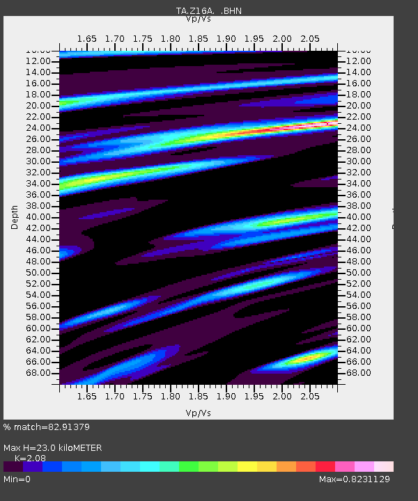
| Estimated Moho Depth: |
23.0 km |
| Estimated Crust Vp/Vs: |
2.08 |
| Assumed Crust Vp: |
6.276 km/s |
| Estimated Crust Vs: |
3.017 km/s |
| Estimated Crust Poisson's Ratio: |
0.35 |
|
| Radial Match: |
82.91379 % |
| Radial Bump: |
400 |
| Transverse Match: |
75.68466 % |
| Transverse Bump: |
400 |
| SOD ConfigId: |
2564 |
| Insert Time: |
2010-03-05 23:30:41.187 +0000 |
| GWidth: |
2.5 |
| Max Bumps: |
400 |
| Tol: |
0.001 |
|
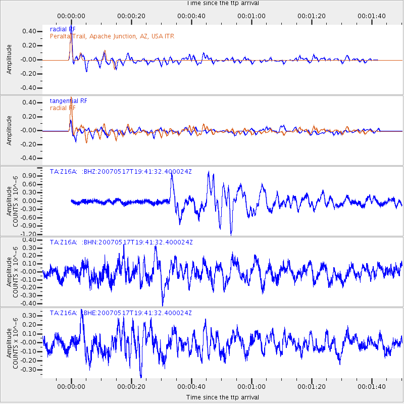
Signal To Noise
| Channel | StoN | STA | LTA |
| TA:Z16A: :BHN:20070517T19:41:32.400024Z | 0.969909 | 6.4443775E-8 | 6.6443114E-8 |
| TA:Z16A: :BHE:20070517T19:41:32.400024Z | 2.12606 | 1.3975003E-7 | 6.573193E-8 |
| TA:Z16A: :BHZ:20070517T19:41:32.400024Z | 6.995688 | 3.592219E-7 | 5.1349048E-8 |
| Arrivals |
| Ps | 4.0 SECOND |
| PpPs | 11 SECOND |
| PsPs/PpSs | 15 SECOND |


