You are here: Home > Network List > TA - USArray Transportable Network (new EarthScope stations) Stations List
> Station Z16A Peralta Trail, Apache Junction, AZ, USA > Earthquake Result Viewer
Z16A Peralta Trail, Apache Junction, AZ, USA - Earthquake Result Viewer

| Earthquake location: |
Iceland |
| Earthquake latitude/longitude: |
64.0/-21.0 |
| Earthquake time(UTC): |
2008/05/29 (150) 15:46:00 GMT |
| Earthquake Depth: |
10 km |
| Earthquake Magnitude: |
6.0 MB, 6.2 MS, 6.3 MW, 6.2 MW |
| Earthquake Catalog/Contributor: |
WHDF/NEIC |
|
| Network: |
TA USArray Transportable Network (new EarthScope stations) |
| Station: |
Z16A Peralta Trail, Apache Junction, AZ, USA |
| Lat/Lon: |
33.34 N/111.43 W |
| Elevation: |
537 m |
|
| Distance: |
60.8 deg |
| Az: |
286.41 deg |
| Baz: |
30.331 deg |
| Ray Param: |
0.06131595 |
| Estimated Moho Depth: |
28.5 km |
| Estimated Crust Vp/Vs: |
1.65 |
| Assumed Crust Vp: |
6.276 km/s |
| Estimated Crust Vs: |
3.804 km/s |
| Estimated Crust Poisson's Ratio: |
0.21 |
|
| Radial Match: |
83.93443 % |
| Radial Bump: |
328 |
| Transverse Match: |
68.31249 % |
| Transverse Bump: |
392 |
| SOD ConfigId: |
2504 |
| Insert Time: |
2010-03-05 23:30:54.598 +0000 |
| GWidth: |
2.5 |
| Max Bumps: |
400 |
| Tol: |
0.001 |
|
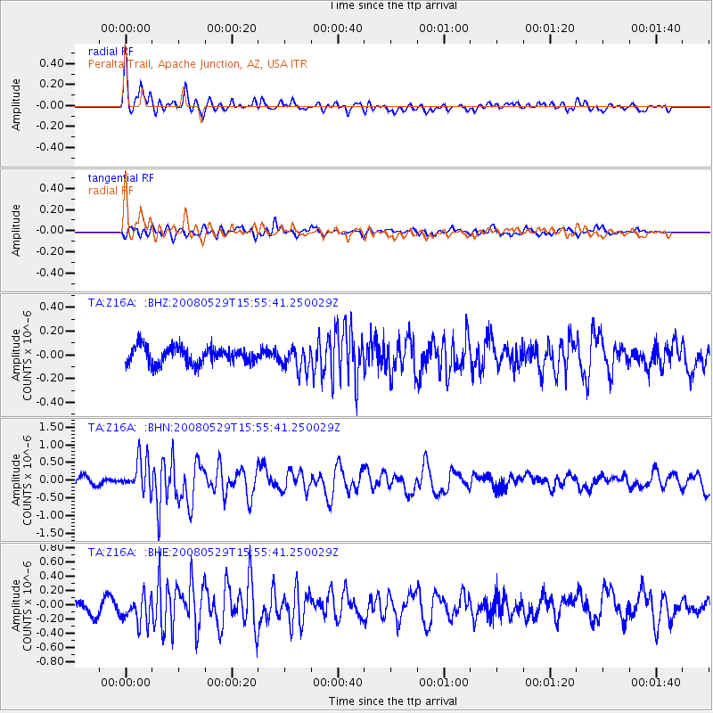
Signal To Noise
| Channel | StoN | STA | LTA |
| TA:Z16A: :BHN:20080529T15:55:41.250029Z | 4.2715845 | 4.671144E-7 | 1.0935389E-7 |
| TA:Z16A: :BHE:20080529T15:55:41.250029Z | 2.4552312 | 1.8915556E-7 | 7.7041854E-8 |
| TA:Z16A: :BHZ:20080529T15:55:41.250029Z | 1.4024124 | 9.8255825E-8 | 7.006201E-8 |
| Arrivals |
| Ps | 3.1 SECOND |
| PpPs | 11 SECOND |
| PsPs/PpSs | 15 SECOND |


