You are here: Home > Network List > TA - USArray Transportable Network (new EarthScope stations) Stations List
> Station Z16A Peralta Trail, Apache Junction, AZ, USA > Earthquake Result Viewer
Z16A Peralta Trail, Apache Junction, AZ, USA - Earthquake Result Viewer
| Earthquake location: |
Kuril Islands |
| Earthquake latitude/longitude: |
51.0/157.6 |
| Earthquake time(UTC): |
2008/07/24 (206) 01:43:16 GMT |
| Earthquake Depth: |
27 km |
| Earthquake Magnitude: |
6.0 MB, 6.0 MS, 6.2 MW, 6.2 MW |
| Earthquake Catalog/Contributor: |
WHDF/NEIC |
|
| Network: |
TA USArray Transportable Network (new EarthScope stations) |
| Station: |
Z16A Peralta Trail, Apache Junction, AZ, USA |
| Lat/Lon: |
33.34 N/111.43 W |
| Elevation: |
537 m |
|
| Distance: |
65.5 deg |
| Az: |
66.894 deg |
| Baz: |
315.991 deg |
| Ray Param: |
0.058191754 |
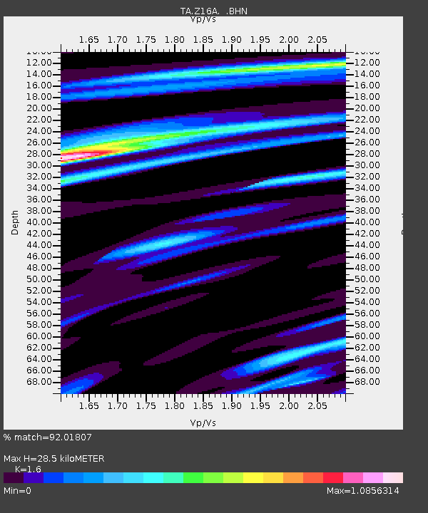
| Estimated Moho Depth: |
28.5 km |
| Estimated Crust Vp/Vs: |
1.60 |
| Assumed Crust Vp: |
6.276 km/s |
| Estimated Crust Vs: |
3.922 km/s |
| Estimated Crust Poisson's Ratio: |
0.18 |
|
| Radial Match: |
92.01807 % |
| Radial Bump: |
381 |
| Transverse Match: |
77.6281 % |
| Transverse Bump: |
400 |
| SOD ConfigId: |
2504 |
| Insert Time: |
2010-03-05 23:31:17.255 +0000 |
| GWidth: |
2.5 |
| Max Bumps: |
400 |
| Tol: |
0.001 |
|
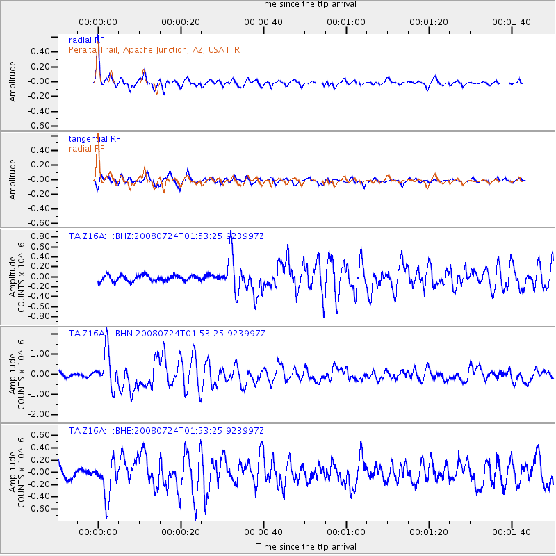
Signal To Noise
| Channel | StoN | STA | LTA |
| TA:Z16A: :BHN:20080724T01:53:25.923997Z | 10.398617 | 9.1295107E-7 | 8.7795435E-8 |
| TA:Z16A: :BHE:20080724T01:53:25.923997Z | 3.10029 | 3.0448632E-7 | 9.8212205E-8 |
| TA:Z16A: :BHZ:20080724T01:53:25.923997Z | 6.507311 | 3.7677296E-7 | 5.7899946E-8 |
| Arrivals |
| Ps | 2.8 SECOND |
| PpPs | 11 SECOND |
| PsPs/PpSs | 14 SECOND |


