You are here: Home > Network List > TA - USArray Transportable Network (new EarthScope stations) Stations List
> Station Z16A Peralta Trail, Apache Junction, AZ, USA > Earthquake Result Viewer
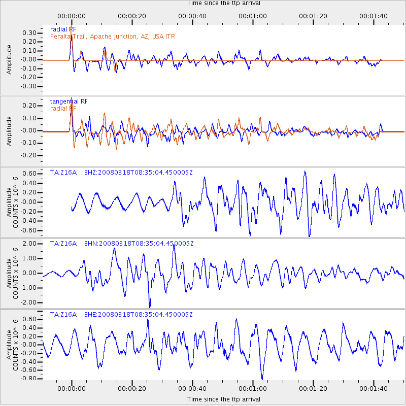
Z16A Peralta Trail, Apache Junction, AZ, USA - Earthquake Result Viewer
*The percent match for this event was below the threshold and hence no stack was calculated.
| Earthquake location: |
Kermadec Islands, New Zealand |
| Earthquake latitude/longitude: |
-29.3/-177.4 |
| Earthquake time(UTC): |
2008/03/18 (078) 08:22:47 GMT |
| Earthquake Depth: |
25 km |
| Earthquake Magnitude: |
5.8 MB, 6.1 MS, 6.2 MW, 6.2 MW |
| Earthquake Catalog/Contributor: |
WHDF/NEIC |
|
| Network: |
TA USArray Transportable Network (new EarthScope stations) |
| Station: |
Z16A Peralta Trail, Apache Junction, AZ, USA |
| Lat/Lon: |
33.34 N/111.43 W |
| Elevation: |
537 m |
|
| Distance: |
88.2 deg |
| Az: |
49.923 deg |
| Baz: |
233.015 deg |
| Ray Param: |
$rayparam |
*The percent match for this event was below the threshold and hence was not used in the summary stack. |
|
| Radial Match: |
62.3464 % |
| Radial Bump: |
400 |
| Transverse Match: |
69.81734 % |
| Transverse Bump: |
400 |
| SOD ConfigId: |
2504 |
| Insert Time: |
2010-03-05 23:31:35.494 +0000 |
| GWidth: |
2.5 |
| Max Bumps: |
400 |
| Tol: |
0.001 |
|
Signal To Noise
| Channel | StoN | STA | LTA |
| TA:Z16A: :BHN:20080318T08:35:04.450005Z | 2.2760212 | 3.7357051E-7 | 1.6413314E-7 |
| TA:Z16A: :BHE:20080318T08:35:04.450005Z | 1.2905073 | 2.2041968E-7 | 1.7080079E-7 |
| TA:Z16A: :BHZ:20080318T08:35:04.450005Z | 1.5242118 | 1.8115325E-7 | 1.1885045E-7 |
| Arrivals |
| Ps | |
| PpPs | |
| PsPs/PpSs | |


