You are here: Home > Network List > US - United States National Seismic Network Stations List
> Station WMOK Wichita Mountains, Oklahoma, USA > Earthquake Result Viewer
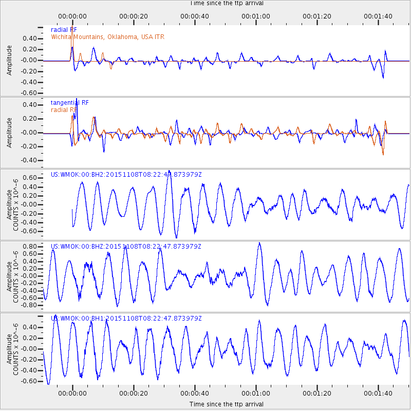
WMOK Wichita Mountains, Oklahoma, USA - Earthquake Result Viewer
*The percent match for this event was below the threshold and hence no stack was calculated.
| Earthquake location: |
Peru-Bolivia Border Region |
| Earthquake latitude/longitude: |
-17.3/-69.5 |
| Earthquake time(UTC): |
2015/11/08 (312) 08:13:36 GMT |
| Earthquake Depth: |
152 km |
| Earthquake Magnitude: |
5.7 MWW, 5.7 MWC, 5.7 MWB |
| Earthquake Catalog/Contributor: |
NEIC PDE/NEIC COMCAT |
|
| Network: |
US United States National Seismic Network |
| Station: |
WMOK Wichita Mountains, Oklahoma, USA |
| Lat/Lon: |
34.74 N/98.78 W |
| Elevation: |
486 m |
|
| Distance: |
58.7 deg |
| Az: |
331.88 deg |
| Baz: |
146.851 deg |
| Ray Param: |
$rayparam |
*The percent match for this event was below the threshold and hence was not used in the summary stack. |
|
| Radial Match: |
30.898497 % |
| Radial Bump: |
400 |
| Transverse Match: |
72.710266 % |
| Transverse Bump: |
388 |
| SOD ConfigId: |
1259291 |
| Insert Time: |
2015-12-11 14:09:27.200 +0000 |
| GWidth: |
2.5 |
| Max Bumps: |
400 |
| Tol: |
0.001 |
|
Signal To Noise
| Channel | StoN | STA | LTA |
| US:WMOK:00:BHZ:20151108T08:22:47.873979Z | 1.1612791 | 3.258003E-7 | 2.80553E-7 |
| US:WMOK:00:BH1:20151108T08:22:47.873979Z | 1.3060385 | 3.5415712E-7 | 2.7116897E-7 |
| US:WMOK:00:BH2:20151108T08:22:47.873979Z | 1.6791351 | 5.3432524E-7 | 3.1821455E-7 |
| Arrivals |
| Ps | |
| PpPs | |
| PsPs/PpSs | |


