You are here: Home > Network List > US - United States National Seismic Network Stations List
> Station AMTX Amarillo, Texas, USA > Earthquake Result Viewer
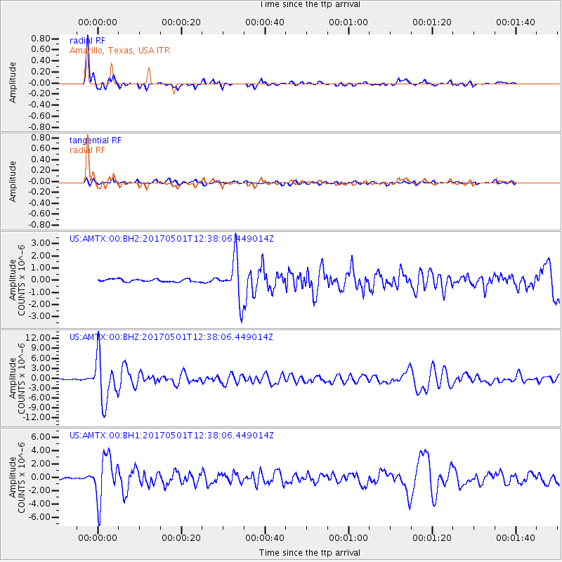
AMTX Amarillo, Texas, USA - Earthquake Result Viewer
*The percent match for this event was below the threshold and hence no stack was calculated.
| Earthquake location: |
Southeastern Alaska |
| Earthquake latitude/longitude: |
59.9/-136.6 |
| Earthquake time(UTC): |
2017/05/01 (121) 12:31:53 GMT |
| Earthquake Depth: |
0.1 km |
| Earthquake Magnitude: |
6.5 Ml |
| Earthquake Catalog/Contributor: |
NEIC PDE/ak |
|
| Network: |
US United States National Seismic Network |
| Station: |
AMTX Amarillo, Texas, USA |
| Lat/Lon: |
34.53 N/101.41 W |
| Elevation: |
1010 m |
|
| Distance: |
34.1 deg |
| Az: |
122.092 deg |
| Baz: |
328.819 deg |
| Ray Param: |
$rayparam |
*The percent match for this event was below the threshold and hence was not used in the summary stack. |
|
| Radial Match: |
93.137856 % |
| Radial Bump: |
304 |
| Transverse Match: |
69.16687 % |
| Transverse Bump: |
400 |
| SOD ConfigId: |
11737051 |
| Insert Time: |
2019-04-27 06:27:26.766 +0000 |
| GWidth: |
2.5 |
| Max Bumps: |
400 |
| Tol: |
0.001 |
|
Signal To Noise
| Channel | StoN | STA | LTA |
| US:AMTX:00:BHZ:20170501T12:38:06.449014Z | 54.192265 | 6.978391E-6 | 1.2877098E-7 |
| US:AMTX:00:BH1:20170501T12:38:06.449014Z | 25.95715 | 3.4024472E-6 | 1.3107939E-7 |
| US:AMTX:00:BH2:20170501T12:38:06.449014Z | 16.92566 | 2.0123769E-6 | 1.1889503E-7 |
| Arrivals |
| Ps | |
| PpPs | |
| PsPs/PpSs | |


