You are here: Home > Network List > TA - USArray Transportable Network (new EarthScope stations) Stations List
> Station Z16A Peralta Trail, Apache Junction, AZ, USA > Earthquake Result Viewer
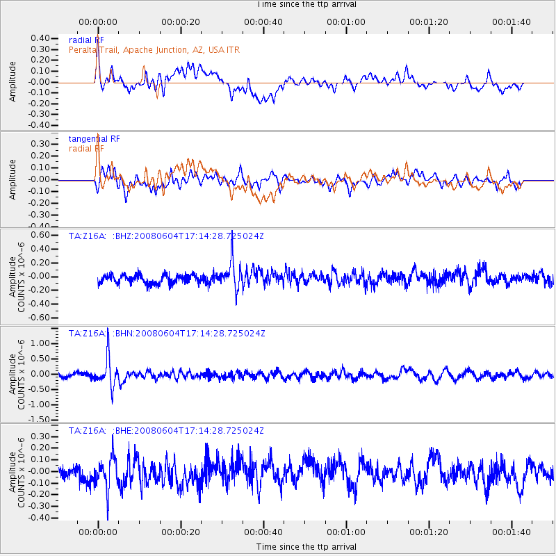
Z16A Peralta Trail, Apache Junction, AZ, USA - Earthquake Result Viewer
*The percent match for this event was below the threshold and hence no stack was calculated.
| Earthquake location: |
Hokkaido, Japan Region |
| Earthquake latitude/longitude: |
41.5/139.0 |
| Earthquake time(UTC): |
2008/06/04 (156) 17:03:07 GMT |
| Earthquake Depth: |
213 km |
| Earthquake Magnitude: |
5.5 MB, 5.7 MW, 5.7 MW |
| Earthquake Catalog/Contributor: |
WHDF/NEIC |
|
| Network: |
TA USArray Transportable Network (new EarthScope stations) |
| Station: |
Z16A Peralta Trail, Apache Junction, AZ, USA |
| Lat/Lon: |
33.34 N/111.43 W |
| Elevation: |
537 m |
|
| Distance: |
81.3 deg |
| Az: |
52.955 deg |
| Baz: |
314.288 deg |
| Ray Param: |
$rayparam |
*The percent match for this event was below the threshold and hence was not used in the summary stack. |
|
| Radial Match: |
58.003506 % |
| Radial Bump: |
400 |
| Transverse Match: |
65.58331 % |
| Transverse Bump: |
400 |
| SOD ConfigId: |
2504 |
| Insert Time: |
2010-03-05 23:31:52.163 +0000 |
| GWidth: |
2.5 |
| Max Bumps: |
400 |
| Tol: |
0.001 |
|
Signal To Noise
| Channel | StoN | STA | LTA |
| TA:Z16A: :BHN:20080604T17:14:28.725024Z | 6.35054 | 4.889426E-7 | 7.699228E-8 |
| TA:Z16A: :BHE:20080604T17:14:28.725024Z | 1.7655517 | 1.3962035E-7 | 7.9080294E-8 |
| TA:Z16A: :BHZ:20080604T17:14:28.725024Z | 3.2905831 | 2.0428469E-7 | 6.208161E-8 |
| Arrivals |
| Ps | |
| PpPs | |
| PsPs/PpSs | |


