You are here: Home > Network List > YR16 - Armatrice Sequence International Stations List
> Station ED16 ASTORARA > Earthquake Result Viewer
ED16 ASTORARA - Earthquake Result Viewer
| Earthquake location: |
Southeastern Alaska |
| Earthquake latitude/longitude: |
59.9/-136.6 |
| Earthquake time(UTC): |
2017/05/01 (121) 12:31:53 GMT |
| Earthquake Depth: |
0.1 km |
| Earthquake Magnitude: |
6.5 Ml |
| Earthquake Catalog/Contributor: |
NEIC PDE/ak |
|
| Network: |
YR Armatrice Sequence International |
| Station: |
ED16 ASTORARA |
| Lat/Lon: |
42.84 N/13.31 E |
| Elevation: |
1039 m |
|
| Distance: |
74.7 deg |
| Az: |
22.507 deg |
| Baz: |
344.777 deg |
| Ray Param: |
0.052178647 |
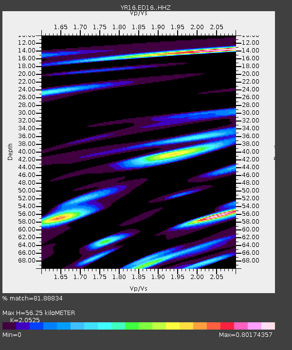
| Estimated Moho Depth: |
56.25 km |
| Estimated Crust Vp/Vs: |
2.05 |
| Assumed Crust Vp: |
6.276 km/s |
| Estimated Crust Vs: |
3.058 km/s |
| Estimated Crust Poisson's Ratio: |
0.34 |
|
| Radial Match: |
81.88834 % |
| Radial Bump: |
400 |
| Transverse Match: |
63.752625 % |
| Transverse Bump: |
400 |
| SOD ConfigId: |
11737051 |
| Insert Time: |
2019-04-27 06:28:12.712 +0000 |
| GWidth: |
2.5 |
| Max Bumps: |
400 |
| Tol: |
0.001 |
|

Signal To Noise
| Channel | StoN | STA | LTA |
| YR:ED16: :HHZ:20170501T12:43:04.340005Z | 5.6417146 | 3.4772406E-6 | 6.1634466E-7 |
| YR:ED16: :HHN:20170501T12:43:04.340005Z | 2.9615617 | 1.1050341E-6 | 3.731255E-7 |
| YR:ED16: :HHE:20170501T12:43:04.340005Z | 1.3913575 | 4.7986873E-7 | 3.448925E-7 |
| Arrivals |
| Ps | 9.7 SECOND |
| PpPs | 27 SECOND |
| PsPs/PpSs | 36 SECOND |


