You are here: Home > Network List > BC - Red Sismica del Noroeste de Mexico Stations List
> Station PIX Pinacate, , SON, MEXICO > Earthquake Result Viewer
PIX Pinacate, , SON, MEXICO - Earthquake Result Viewer
| Earthquake location: |
Southeastern Alaska |
| Earthquake latitude/longitude: |
59.8/-136.6 |
| Earthquake time(UTC): |
2017/05/01 (121) 14:18:15 GMT |
| Earthquake Depth: |
3.3 km |
| Earthquake Magnitude: |
6.3 Ml |
| Earthquake Catalog/Contributor: |
NEIC PDE/ak |
|
| Network: |
BC Red Sismica del Noroeste de Mexico |
| Station: |
PIX Pinacate, , SON, MEXICO |
| Lat/Lon: |
31.56 N/113.46 W |
| Elevation: |
78 m |
|
| Distance: |
32.2 deg |
| Az: |
140.999 deg |
| Baz: |
338.151 deg |
| Ray Param: |
0.07874997 |
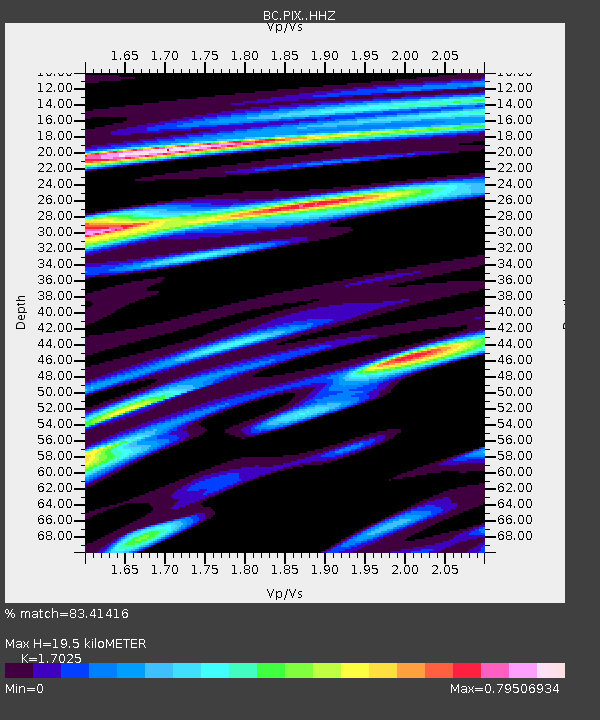
| Estimated Moho Depth: |
19.5 km |
| Estimated Crust Vp/Vs: |
1.70 |
| Assumed Crust Vp: |
6.276 km/s |
| Estimated Crust Vs: |
3.686 km/s |
| Estimated Crust Poisson's Ratio: |
0.24 |
|
| Radial Match: |
83.41416 % |
| Radial Bump: |
400 |
| Transverse Match: |
63.115192 % |
| Transverse Bump: |
400 |
| SOD ConfigId: |
11737051 |
| Insert Time: |
2019-04-27 06:29:54.332 +0000 |
| GWidth: |
2.5 |
| Max Bumps: |
400 |
| Tol: |
0.001 |
|

Signal To Noise
| Channel | StoN | STA | LTA |
| BC:PIX: :HHZ:20170501T14:24:14.265013Z | 4.844813 | 9.634558E-7 | 1.9886336E-7 |
| BC:PIX: :HHN:20170501T14:24:14.265013Z | 7.2266984 | 6.53951E-7 | 9.049098E-8 |
| BC:PIX: :HHE:20170501T14:24:14.265013Z | 1.3465368 | 2.3958606E-7 | 1.7792762E-7 |
| Arrivals |
| Ps | 2.4 SECOND |
| PpPs | 7.8 SECOND |
| PsPs/PpSs | 10 SECOND |


