You are here: Home > Network List > CN - Canadian National Seismograph Network Stations List
> Station TRQ Mont-Tremblant, QC, CA > Earthquake Result Viewer
TRQ Mont-Tremblant, QC, CA - Earthquake Result Viewer
| Earthquake location: |
Southeastern Alaska |
| Earthquake latitude/longitude: |
59.8/-136.6 |
| Earthquake time(UTC): |
2017/05/01 (121) 14:18:15 GMT |
| Earthquake Depth: |
3.3 km |
| Earthquake Magnitude: |
6.3 Ml |
| Earthquake Catalog/Contributor: |
NEIC PDE/ak |
|
| Network: |
CN Canadian National Seismograph Network |
| Station: |
TRQ Mont-Tremblant, QC, CA |
| Lat/Lon: |
46.22 N/74.55 W |
| Elevation: |
860 m |
|
| Distance: |
38.2 deg |
| Az: |
82.339 deg |
| Baz: |
313.9 deg |
| Ray Param: |
0.0756927 |
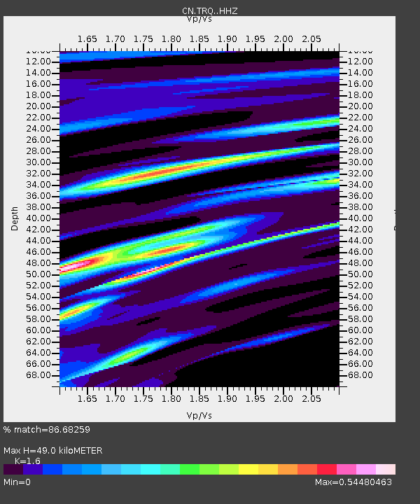
| Estimated Moho Depth: |
49.0 km |
| Estimated Crust Vp/Vs: |
1.60 |
| Assumed Crust Vp: |
6.61 km/s |
| Estimated Crust Vs: |
4.131 km/s |
| Estimated Crust Poisson's Ratio: |
0.18 |
|
| Radial Match: |
86.68259 % |
| Radial Bump: |
201 |
| Transverse Match: |
58.750652 % |
| Transverse Bump: |
400 |
| SOD ConfigId: |
11737051 |
| Insert Time: |
2019-04-27 06:30:25.665 +0000 |
| GWidth: |
2.5 |
| Max Bumps: |
400 |
| Tol: |
0.001 |
|

Signal To Noise
| Channel | StoN | STA | LTA |
| CN:TRQ: :HHZ:20170501T14:25:06.100005Z | 2.4437392 | 5.131773E-7 | 2.0999677E-7 |
| CN:TRQ: :HHN:20170501T14:25:06.100005Z | 1.9087365 | 3.672636E-7 | 1.924119E-7 |
| CN:TRQ: :HHE:20170501T14:25:06.100005Z | 1.7847109 | 3.3683747E-7 | 1.8873504E-7 |
| Arrivals |
| Ps | 4.8 SECOND |
| PpPs | 18 SECOND |
| PsPs/PpSs | 23 SECOND |


