You are here: Home > Network List > TA - USArray Transportable Network (new EarthScope stations) Stations List
> Station 529A Stev Forest Ranch, Sanderson, TX, USA > Earthquake Result Viewer
529A Stev Forest Ranch, Sanderson, TX, USA - Earthquake Result Viewer

| Earthquake location: |
Kuril Islands |
| Earthquake latitude/longitude: |
48.3/154.2 |
| Earthquake time(UTC): |
2009/09/10 (253) 02:46:50 GMT |
| Earthquake Depth: |
36 km |
| Earthquake Magnitude: |
6.0 MB, 5.5 MS, 6.0 MW, 5.8 MW |
| Earthquake Catalog/Contributor: |
WHDF/NEIC |
|
| Network: |
TA USArray Transportable Network (new EarthScope stations) |
| Station: |
529A Stev Forest Ranch, Sanderson, TX, USA |
| Lat/Lon: |
30.12 N/102.22 W |
| Elevation: |
764 m |
|
| Distance: |
76.4 deg |
| Az: |
60.068 deg |
| Baz: |
318.113 deg |
| Ray Param: |
0.050998747 |
| Estimated Moho Depth: |
29.0 km |
| Estimated Crust Vp/Vs: |
2.05 |
| Assumed Crust Vp: |
6.121 km/s |
| Estimated Crust Vs: |
2.982 km/s |
| Estimated Crust Poisson's Ratio: |
0.34 |
|
| Radial Match: |
85.0865 % |
| Radial Bump: |
366 |
| Transverse Match: |
69.90428 % |
| Transverse Bump: |
400 |
| SOD ConfigId: |
2622 |
| Insert Time: |
2010-03-05 23:32:27.366 +0000 |
| GWidth: |
2.5 |
| Max Bumps: |
400 |
| Tol: |
0.001 |
|
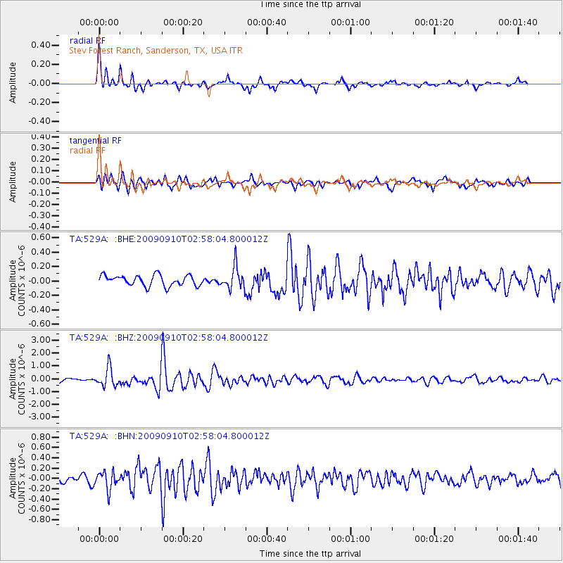
Signal To Noise
| Channel | StoN | STA | LTA |
| TA:529A: :BHZ:20090910T02:58:04.800012Z | 6.8830047 | 7.391803E-7 | 1.073921E-7 |
| TA:529A: :BHN:20090910T02:58:04.800012Z | 2.4224753 | 1.7335294E-7 | 7.156025E-8 |
| TA:529A: :BHE:20090910T02:58:04.800012Z | 2.1632218 | 1.5870938E-7 | 7.336713E-8 |
| Arrivals |
| Ps | 5.1 SECOND |
| PpPs | 14 SECOND |
| PsPs/PpSs | 19 SECOND |


