You are here: Home > Network List > TA - USArray Transportable Network (new EarthScope stations) Stations List
> Station 529A Stev Forest Ranch, Sanderson, TX, USA > Earthquake Result Viewer
529A Stev Forest Ranch, Sanderson, TX, USA - Earthquake Result Viewer
| Earthquake location: |
Rat Islands, Aleutian Islands |
| Earthquake latitude/longitude: |
50.4/177.0 |
| Earthquake time(UTC): |
2009/07/06 (187) 14:53:12 GMT |
| Earthquake Depth: |
22 km |
| Earthquake Magnitude: |
6.0 MB, 5.8 MS, 6.1 MW, 6.0 MW |
| Earthquake Catalog/Contributor: |
WHDF/NEIC |
|
| Network: |
TA USArray Transportable Network (new EarthScope stations) |
| Station: |
529A Stev Forest Ranch, Sanderson, TX, USA |
| Lat/Lon: |
30.12 N/102.22 W |
| Elevation: |
764 m |
|
| Distance: |
61.8 deg |
| Az: |
76.033 deg |
| Baz: |
314.251 deg |
| Ray Param: |
0.06061972 |
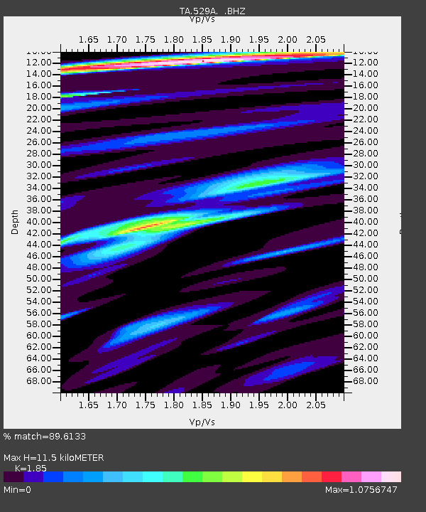
| Estimated Moho Depth: |
11.5 km |
| Estimated Crust Vp/Vs: |
1.85 |
| Assumed Crust Vp: |
6.121 km/s |
| Estimated Crust Vs: |
3.308 km/s |
| Estimated Crust Poisson's Ratio: |
0.29 |
|
| Radial Match: |
89.6133 % |
| Radial Bump: |
351 |
| Transverse Match: |
68.97452 % |
| Transverse Bump: |
400 |
| SOD ConfigId: |
2648 |
| Insert Time: |
2010-03-05 23:32:45.537 +0000 |
| GWidth: |
2.5 |
| Max Bumps: |
400 |
| Tol: |
0.001 |
|

Signal To Noise
| Channel | StoN | STA | LTA |
| TA:529A: :BHZ:20090706T15:02:58.25001Z | 15.637089 | 1.8878831E-6 | 1.2073112E-7 |
| TA:529A: :BHN:20090706T15:02:58.25001Z | 2.3608341 | 4.754041E-7 | 2.0137125E-7 |
| TA:529A: :BHE:20090706T15:02:58.25001Z | 3.8895586 | 4.920164E-7 | 1.2649673E-7 |
| Arrivals |
| Ps | 1.7 SECOND |
| PpPs | 5.2 SECOND |
| PsPs/PpSs | 6.8 SECOND |


