You are here: Home > Network List > TA - USArray Transportable Network (new EarthScope stations) Stations List
> Station 529A Stev Forest Ranch, Sanderson, TX, USA > Earthquake Result Viewer
529A Stev Forest Ranch, Sanderson, TX, USA - Earthquake Result Viewer
| Earthquake location: |
Baffin Bay |
| Earthquake latitude/longitude: |
75.4/-72.5 |
| Earthquake time(UTC): |
2009/07/07 (188) 19:11:46 GMT |
| Earthquake Depth: |
19 km |
| Earthquake Magnitude: |
5.9 MB, 5.7 MS, 6.1 MW, 6.0 MW |
| Earthquake Catalog/Contributor: |
WHDF/NEIC |
|
| Network: |
TA USArray Transportable Network (new EarthScope stations) |
| Station: |
529A Stev Forest Ranch, Sanderson, TX, USA |
| Lat/Lon: |
30.12 N/102.22 W |
| Elevation: |
764 m |
|
| Distance: |
47.6 deg |
| Az: |
215.627 deg |
| Baz: |
9.852 deg |
| Ray Param: |
0.069863185 |
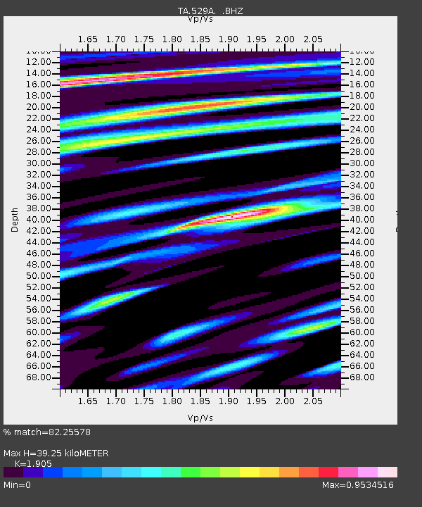
| Estimated Moho Depth: |
39.25 km |
| Estimated Crust Vp/Vs: |
1.90 |
| Assumed Crust Vp: |
6.121 km/s |
| Estimated Crust Vs: |
3.213 km/s |
| Estimated Crust Poisson's Ratio: |
0.31 |
|
| Radial Match: |
82.25578 % |
| Radial Bump: |
400 |
| Transverse Match: |
63.80041 % |
| Transverse Bump: |
400 |
| SOD ConfigId: |
2648 |
| Insert Time: |
2010-03-05 23:32:47.126 +0000 |
| GWidth: |
2.5 |
| Max Bumps: |
400 |
| Tol: |
0.001 |
|
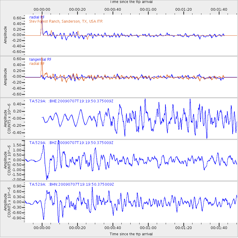
Signal To Noise
| Channel | StoN | STA | LTA |
| TA:529A: :BHZ:20090707T19:19:50.375009Z | 10.151023 | 1.0923648E-6 | 1.076113E-7 |
| TA:529A: :BHN:20090707T19:19:50.375009Z | 6.2175026 | 4.8416564E-7 | 7.78714E-8 |
| TA:529A: :BHE:20090707T19:19:50.375009Z | 1.1326027 | 1.2717454E-7 | 1.1228522E-7 |
| Arrivals |
| Ps | 6.1 SECOND |
| PpPs | 18 SECOND |
| PsPs/PpSs | 24 SECOND |


