You are here: Home > Network List > OK - Oklahoma Seismic Network Stations List
> Station W35A Tecumseh, Oklahoma, USA > Earthquake Result Viewer
W35A Tecumseh, Oklahoma, USA - Earthquake Result Viewer
| Earthquake location: |
Southeastern Alaska |
| Earthquake latitude/longitude: |
59.8/-136.6 |
| Earthquake time(UTC): |
2017/05/01 (121) 14:18:15 GMT |
| Earthquake Depth: |
3.3 km |
| Earthquake Magnitude: |
6.3 Ml |
| Earthquake Catalog/Contributor: |
NEIC PDE/ak |
|
| Network: |
OK Oklahoma Seismic Network |
| Station: |
W35A Tecumseh, Oklahoma, USA |
| Lat/Lon: |
35.15 N/96.87 W |
| Elevation: |
322 m |
|
| Distance: |
35.6 deg |
| Az: |
115.914 deg |
| Baz: |
326.351 deg |
| Ray Param: |
0.07713905 |
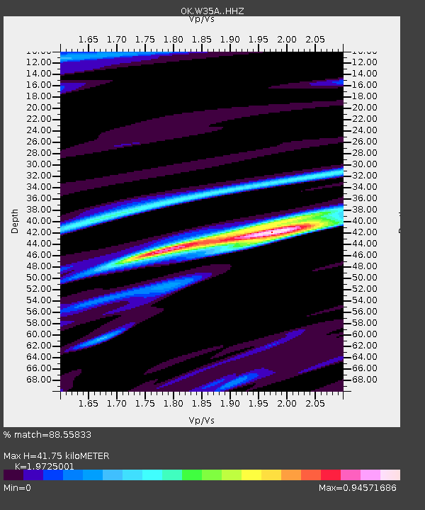
| Estimated Moho Depth: |
41.75 km |
| Estimated Crust Vp/Vs: |
1.97 |
| Assumed Crust Vp: |
6.426 km/s |
| Estimated Crust Vs: |
3.258 km/s |
| Estimated Crust Poisson's Ratio: |
0.33 |
|
| Radial Match: |
88.55833 % |
| Radial Bump: |
338 |
| Transverse Match: |
56.040257 % |
| Transverse Bump: |
394 |
| SOD ConfigId: |
11737051 |
| Insert Time: |
2019-04-27 06:34:17.670 +0000 |
| GWidth: |
2.5 |
| Max Bumps: |
400 |
| Tol: |
0.001 |
|

Signal To Noise
| Channel | StoN | STA | LTA |
| OK:W35A: :HHZ:20170501T14:24:43.760009Z | 4.785779 | 1.0245044E-6 | 2.1407264E-7 |
| OK:W35A: :HHN:20170501T14:24:43.760009Z | 2.9179826 | 5.658107E-7 | 1.9390477E-7 |
| OK:W35A: :HHE:20170501T14:24:43.760009Z | 1.3844261 | 3.4071928E-7 | 2.4610867E-7 |
| Arrivals |
| Ps | 6.8 SECOND |
| PpPs | 18 SECOND |
| PsPs/PpSs | 25 SECOND |


