You are here: Home > Network List > TA - USArray Transportable Network (new EarthScope stations) Stations List
> Station L61B Northampton, MA, USA > Earthquake Result Viewer
L61B Northampton, MA, USA - Earthquake Result Viewer
| Earthquake location: |
Southeastern Alaska |
| Earthquake latitude/longitude: |
59.8/-136.6 |
| Earthquake time(UTC): |
2017/05/01 (121) 14:18:15 GMT |
| Earthquake Depth: |
3.3 km |
| Earthquake Magnitude: |
6.3 Ml |
| Earthquake Catalog/Contributor: |
NEIC PDE/ak |
|
| Network: |
TA USArray Transportable Network (new EarthScope stations) |
| Station: |
L61B Northampton, MA, USA |
| Lat/Lon: |
42.45 N/72.68 W |
| Elevation: |
261 m |
|
| Distance: |
41.9 deg |
| Az: |
84.948 deg |
| Baz: |
317.202 deg |
| Ray Param: |
0.07353516 |
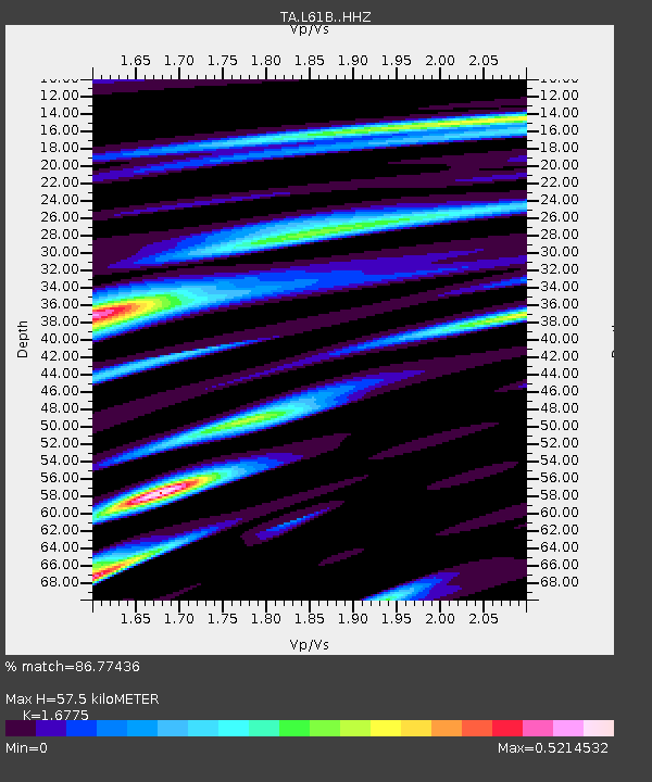
| Estimated Moho Depth: |
57.5 km |
| Estimated Crust Vp/Vs: |
1.68 |
| Assumed Crust Vp: |
6.419 km/s |
| Estimated Crust Vs: |
3.827 km/s |
| Estimated Crust Poisson's Ratio: |
0.22 |
|
| Radial Match: |
86.77436 % |
| Radial Bump: |
265 |
| Transverse Match: |
72.1995 % |
| Transverse Bump: |
364 |
| SOD ConfigId: |
11737051 |
| Insert Time: |
2019-04-27 06:35:22.562 +0000 |
| GWidth: |
2.5 |
| Max Bumps: |
400 |
| Tol: |
0.001 |
|

Signal To Noise
| Channel | StoN | STA | LTA |
| TA:L61B: :HHZ:20170501T14:25:36.179991Z | 1.8561498 | 5.615907E-7 | 3.0255677E-7 |
| TA:L61B: :HHN:20170501T14:25:36.179991Z | 0.57342935 | 1.2807385E-7 | 2.2334721E-7 |
| TA:L61B: :HHE:20170501T14:25:36.179991Z | 1.4036978 | 3.073885E-7 | 2.189848E-7 |
| Arrivals |
| Ps | 6.5 SECOND |
| PpPs | 22 SECOND |
| PsPs/PpSs | 29 SECOND |


