You are here: Home > Network List > TA - USArray Transportable Network (new EarthScope stations) Stations List
> Station M53A WI Miller and Sons, Farmdale, OH, USA > Earthquake Result Viewer
M53A WI Miller and Sons, Farmdale, OH, USA - Earthquake Result Viewer
| Earthquake location: |
Southeastern Alaska |
| Earthquake latitude/longitude: |
59.8/-136.6 |
| Earthquake time(UTC): |
2017/05/01 (121) 14:18:15 GMT |
| Earthquake Depth: |
3.3 km |
| Earthquake Magnitude: |
6.3 Ml |
| Earthquake Catalog/Contributor: |
NEIC PDE/ak |
|
| Network: |
TA USArray Transportable Network (new EarthScope stations) |
| Station: |
M53A WI Miller and Sons, Farmdale, OH, USA |
| Lat/Lon: |
41.44 N/80.68 W |
| Elevation: |
334 m |
|
| Distance: |
38.6 deg |
| Az: |
92.815 deg |
| Baz: |
317.886 deg |
| Ray Param: |
0.07549485 |
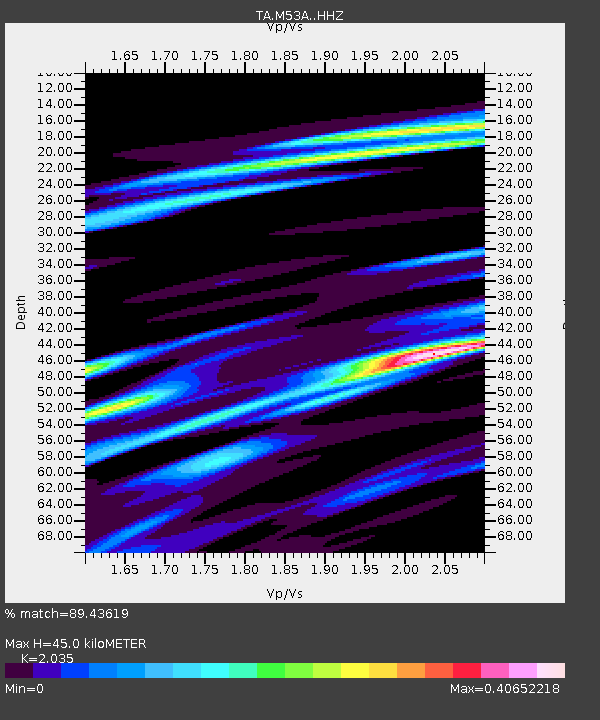
| Estimated Moho Depth: |
45.0 km |
| Estimated Crust Vp/Vs: |
2.04 |
| Assumed Crust Vp: |
6.483 km/s |
| Estimated Crust Vs: |
3.186 km/s |
| Estimated Crust Poisson's Ratio: |
0.34 |
|
| Radial Match: |
89.43619 % |
| Radial Bump: |
262 |
| Transverse Match: |
53.416016 % |
| Transverse Bump: |
400 |
| SOD ConfigId: |
11737051 |
| Insert Time: |
2019-04-27 06:35:23.792 +0000 |
| GWidth: |
2.5 |
| Max Bumps: |
400 |
| Tol: |
0.001 |
|
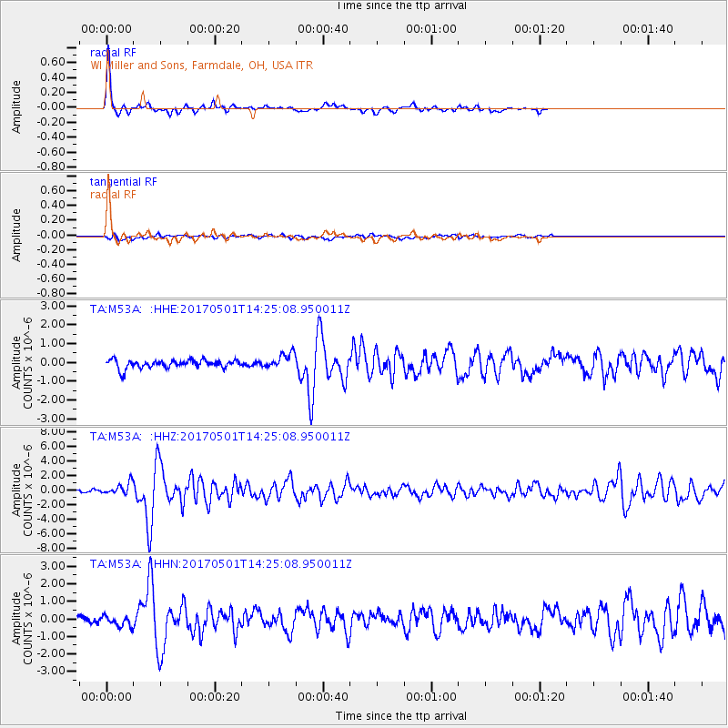
Signal To Noise
| Channel | StoN | STA | LTA |
| TA:M53A: :HHZ:20170501T14:25:08.950011Z | 3.5782127 | 8.081862E-7 | 2.258631E-7 |
| TA:M53A: :HHN:20170501T14:25:08.950011Z | 1.4528223 | 2.884782E-7 | 1.9856398E-7 |
| TA:M53A: :HHE:20170501T14:25:08.950011Z | 1.6784191 | 3.7356205E-7 | 2.225678E-7 |
| Arrivals |
| Ps | 7.7 SECOND |
| PpPs | 20 SECOND |
| PsPs/PpSs | 27 SECOND |


