You are here: Home > Network List > TA - USArray Transportable Network (new EarthScope stations) Stations List
> Station P49A Miami Univ. Ecology Research Center, OH, USA > Earthquake Result Viewer
P49A Miami Univ. Ecology Research Center, OH, USA - Earthquake Result Viewer
| Earthquake location: |
Southeastern Alaska |
| Earthquake latitude/longitude: |
59.8/-136.6 |
| Earthquake time(UTC): |
2017/05/01 (121) 14:18:15 GMT |
| Earthquake Depth: |
3.3 km |
| Earthquake Magnitude: |
6.3 Ml |
| Earthquake Catalog/Contributor: |
NEIC PDE/ak |
|
| Network: |
TA USArray Transportable Network (new EarthScope stations) |
| Station: |
P49A Miami Univ. Ecology Research Center, OH, USA |
| Lat/Lon: |
39.53 N/84.72 W |
| Elevation: |
272 m |
|
| Distance: |
38.0 deg |
| Az: |
98.583 deg |
| Baz: |
319.8 deg |
| Ray Param: |
0.07584017 |
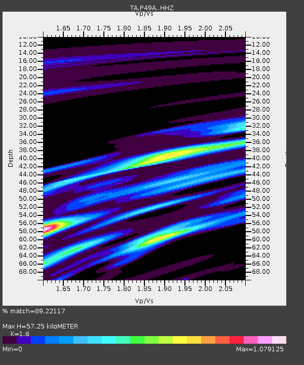
| Estimated Moho Depth: |
57.25 km |
| Estimated Crust Vp/Vs: |
1.60 |
| Assumed Crust Vp: |
6.498 km/s |
| Estimated Crust Vs: |
4.061 km/s |
| Estimated Crust Poisson's Ratio: |
0.18 |
|
| Radial Match: |
89.22117 % |
| Radial Bump: |
331 |
| Transverse Match: |
58.334843 % |
| Transverse Bump: |
400 |
| SOD ConfigId: |
11737051 |
| Insert Time: |
2019-04-27 06:35:25.372 +0000 |
| GWidth: |
2.5 |
| Max Bumps: |
400 |
| Tol: |
0.001 |
|

Signal To Noise
| Channel | StoN | STA | LTA |
| TA:P49A: :HHZ:20170501T14:25:03.910002Z | 2.0169444 | 5.6026903E-7 | 2.777811E-7 |
| TA:P49A: :HHN:20170501T14:25:03.910002Z | 2.3252475 | 4.2832056E-7 | 1.842043E-7 |
| TA:P49A: :HHE:20170501T14:25:03.910002Z | 1.4927614 | 2.9242867E-7 | 1.958978E-7 |
| Arrivals |
| Ps | 5.7 SECOND |
| PpPs | 21 SECOND |
| PsPs/PpSs | 27 SECOND |


