You are here: Home > Network List > TA - USArray Transportable Network (new EarthScope stations) Stations List
> Station P52A Corning, OH, USA > Earthquake Result Viewer
P52A Corning, OH, USA - Earthquake Result Viewer
| Earthquake location: |
Southeastern Alaska |
| Earthquake latitude/longitude: |
59.8/-136.6 |
| Earthquake time(UTC): |
2017/05/01 (121) 14:18:15 GMT |
| Earthquake Depth: |
3.3 km |
| Earthquake Magnitude: |
6.3 Ml |
| Earthquake Catalog/Contributor: |
NEIC PDE/ak |
|
| Network: |
TA USArray Transportable Network (new EarthScope stations) |
| Station: |
P52A Corning, OH, USA |
| Lat/Lon: |
39.63 N/82.13 W |
| Elevation: |
293 m |
|
| Distance: |
39.2 deg |
| Az: |
96.041 deg |
| Baz: |
319.453 deg |
| Ray Param: |
0.075136095 |
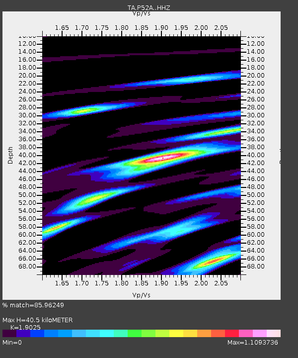
| Estimated Moho Depth: |
40.5 km |
| Estimated Crust Vp/Vs: |
1.90 |
| Assumed Crust Vp: |
6.232 km/s |
| Estimated Crust Vs: |
3.275 km/s |
| Estimated Crust Poisson's Ratio: |
0.31 |
|
| Radial Match: |
85.96249 % |
| Radial Bump: |
306 |
| Transverse Match: |
54.33601 % |
| Transverse Bump: |
400 |
| SOD ConfigId: |
11737051 |
| Insert Time: |
2019-04-27 06:35:26.990 +0000 |
| GWidth: |
2.5 |
| Max Bumps: |
400 |
| Tol: |
0.001 |
|

Signal To Noise
| Channel | StoN | STA | LTA |
| TA:P52A: :HHZ:20170501T14:25:14.130004Z | 4.4430847 | 7.8368765E-7 | 1.763837E-7 |
| TA:P52A: :HHN:20170501T14:25:14.130004Z | 1.5363604 | 2.9004173E-7 | 1.8878497E-7 |
| TA:P52A: :HHE:20170501T14:25:14.130004Z | 1.6312413 | 3.4955113E-7 | 2.1428535E-7 |
| Arrivals |
| Ps | 6.2 SECOND |
| PpPs | 18 SECOND |
| PsPs/PpSs | 24 SECOND |


