You are here: Home > Network List > TA - USArray Transportable Network (new EarthScope stations) Stations List
> Station 529A Stev Forest Ranch, Sanderson, TX, USA > Earthquake Result Viewer
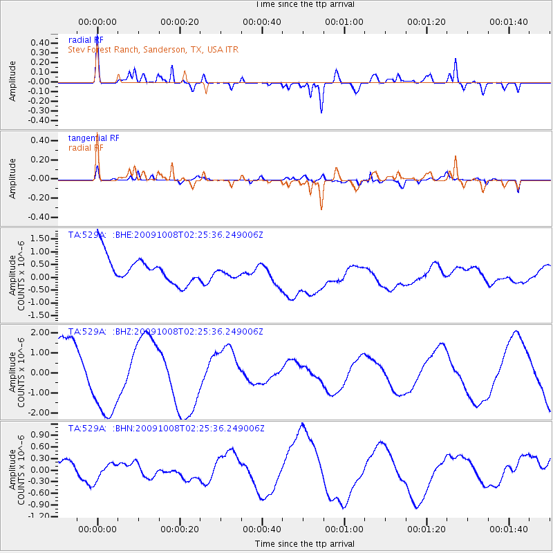
529A Stev Forest Ranch, Sanderson, TX, USA - Earthquake Result Viewer
*The percent match for this event was below the threshold and hence no stack was calculated.
| Earthquake location: |
Santa Cruz Islands |
| Earthquake latitude/longitude: |
-11.7/166.2 |
| Earthquake time(UTC): |
2009/10/08 (281) 02:12:39 GMT |
| Earthquake Depth: |
35 km |
| Earthquake Magnitude: |
5.8 MB, 6.6 MW |
| Earthquake Catalog/Contributor: |
WHDF/NEIC |
|
| Network: |
TA USArray Transportable Network (new EarthScope stations) |
| Station: |
529A Stev Forest Ranch, Sanderson, TX, USA |
| Lat/Lon: |
30.12 N/102.22 W |
| Elevation: |
764 m |
|
| Distance: |
97.1 deg |
| Az: |
60.785 deg |
| Baz: |
260.704 deg |
| Ray Param: |
$rayparam |
*The percent match for this event was below the threshold and hence was not used in the summary stack. |
|
| Radial Match: |
66.52574 % |
| Radial Bump: |
400 |
| Transverse Match: |
59.954994 % |
| Transverse Bump: |
342 |
| SOD ConfigId: |
2622 |
| Insert Time: |
2010-03-05 23:33:09.872 +0000 |
| GWidth: |
2.5 |
| Max Bumps: |
400 |
| Tol: |
0.001 |
|
Signal To Noise
| Channel | StoN | STA | LTA |
| TA:529A: :BHZ:20091008T02:25:36.249006Z | 1.9184978 | 2.256996E-6 | 1.1764391E-6 |
| TA:529A: :BHN:20091008T02:25:36.249006Z | 0.67586595 | 2.0090508E-7 | 2.972558E-7 |
| TA:529A: :BHE:20091008T02:25:36.249006Z | 0.34661737 | 1.7684569E-7 | 5.1020436E-7 |
| Arrivals |
| Ps | |
| PpPs | |
| PsPs/PpSs | |


