You are here: Home > Network List > YX16 - Raton Basin UNM Broadband Network Stations List
> Station UNM2 SE Corner of NM Stations > Earthquake Result Viewer
UNM2 SE Corner of NM Stations - Earthquake Result Viewer
| Earthquake location: |
Southeastern Alaska |
| Earthquake latitude/longitude: |
59.8/-136.6 |
| Earthquake time(UTC): |
2017/05/01 (121) 14:18:15 GMT |
| Earthquake Depth: |
3.3 km |
| Earthquake Magnitude: |
6.3 Ml |
| Earthquake Catalog/Contributor: |
NEIC PDE/ak |
|
| Network: |
YX Raton Basin UNM Broadband Network |
| Station: |
UNM2 SE Corner of NM Stations |
| Lat/Lon: |
36.80 N/104.86 W |
| Elevation: |
2166 m |
|
| Distance: |
30.7 deg |
| Az: |
124.29 deg |
| Baz: |
328.693 deg |
| Ray Param: |
0.079258695 |
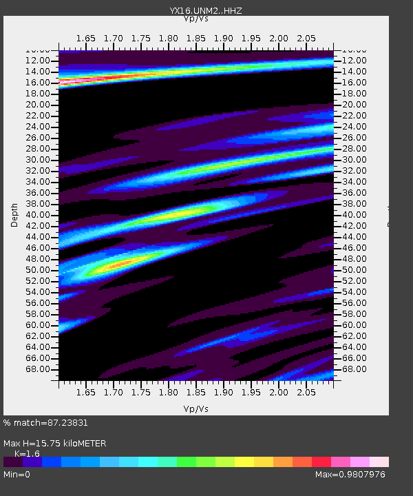
| Estimated Moho Depth: |
15.75 km |
| Estimated Crust Vp/Vs: |
1.60 |
| Assumed Crust Vp: |
6.316 km/s |
| Estimated Crust Vs: |
3.947 km/s |
| Estimated Crust Poisson's Ratio: |
0.18 |
|
| Radial Match: |
87.23831 % |
| Radial Bump: |
281 |
| Transverse Match: |
52.29918 % |
| Transverse Bump: |
387 |
| SOD ConfigId: |
11737051 |
| Insert Time: |
2019-04-27 06:36:42.758 +0000 |
| GWidth: |
2.5 |
| Max Bumps: |
400 |
| Tol: |
0.001 |
|

Signal To Noise
| Channel | StoN | STA | LTA |
| YX:UNM2: :HHZ:20170501T14:24:01.299987Z | 2.8183136 | 6.859395E-7 | 2.433865E-7 |
| YX:UNM2: :HHN:20170501T14:24:01.299987Z | 0.8812467 | 2.1192717E-7 | 2.4048563E-7 |
| YX:UNM2: :HHE:20170501T14:24:01.299987Z | 2.052629 | 3.5889374E-7 | 1.7484588E-7 |
| Arrivals |
| Ps | 1.6 SECOND |
| PpPs | 5.9 SECOND |
| PsPs/PpSs | 7.6 SECOND |


