You are here: Home > Network List > TA - USArray Transportable Network (new EarthScope stations) Stations List
> Station V15A Kaibab National Forest USFS, William, AZ, USA > Earthquake Result Viewer
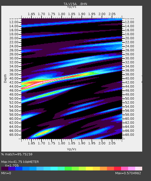
V15A Kaibab National Forest USFS, William, AZ, USA - Earthquake Result Viewer
| Earthquake location: |
South Of Fiji Islands |
| Earthquake latitude/longitude: |
-26.0/-177.5 |
| Earthquake time(UTC): |
2007/12/09 (343) 07:28:20 GMT |
| Earthquake Depth: |
152 km |
| Earthquake Magnitude: |
7.0 MB, 7.8 MW, 7.7 MW |
| Earthquake Catalog/Contributor: |
WHDF/NEIC |
|
| Network: |
TA USArray Transportable Network (new EarthScope stations) |
| Station: |
V15A Kaibab National Forest USFS, William, AZ, USA |
| Lat/Lon: |
35.82 N/112.17 W |
| Elevation: |
1891 m |
|
| Distance: |
87.1 deg |
| Az: |
47.696 deg |
| Baz: |
234.983 deg |
| Ray Param: |
0.043257043 |
| Estimated Moho Depth: |
41.75 km |
| Estimated Crust Vp/Vs: |
1.71 |
| Assumed Crust Vp: |
6.276 km/s |
| Estimated Crust Vs: |
3.681 km/s |
| Estimated Crust Poisson's Ratio: |
0.24 |
|
| Radial Match: |
95.75159 % |
| Radial Bump: |
316 |
| Transverse Match: |
90.23609 % |
| Transverse Bump: |
399 |
| SOD ConfigId: |
2564 |
| Insert Time: |
2010-03-05 23:33:29.844 +0000 |
| GWidth: |
2.5 |
| Max Bumps: |
400 |
| Tol: |
0.001 |
|

Signal To Noise
| Channel | StoN | STA | LTA |
| TA:V15A: :BHN:20071209T07:40:17.999016Z | 0.9210418 | 1.8200876E-7 | 1.9761184E-7 |
| TA:V15A: :BHE:20071209T07:40:17.999016Z | 2.007425 | 3.4769786E-7 | 1.732059E-7 |
| TA:V15A: :BHZ:20071209T07:40:17.999016Z | 4.301183 | 1.0585344E-6 | 2.4610307E-7 |
| Arrivals |
| Ps | 4.8 SECOND |
| PpPs | 18 SECOND |
| PsPs/PpSs | 22 SECOND |


