You are here: Home > Network List > TA - USArray Transportable Network (new EarthScope stations) Stations List
> Station V15A Kaibab National Forest USFS, William, AZ, USA > Earthquake Result Viewer
V15A Kaibab National Forest USFS, William, AZ, USA - Earthquake Result Viewer

| Earthquake location: |
Solomon Islands |
| Earthquake latitude/longitude: |
-10.9/162.1 |
| Earthquake time(UTC): |
2007/11/27 (331) 11:49:58 GMT |
| Earthquake Depth: |
16 km |
| Earthquake Magnitude: |
5.9 MB, 6.7 MS, 6.6 MW, 6.4 MW |
| Earthquake Catalog/Contributor: |
WHDF/NEIC |
|
| Network: |
TA USArray Transportable Network (new EarthScope stations) |
| Station: |
V15A Kaibab National Forest USFS, William, AZ, USA |
| Lat/Lon: |
35.82 N/112.17 W |
| Elevation: |
1891 m |
|
| Distance: |
92.9 deg |
| Az: |
54.235 deg |
| Baz: |
258.653 deg |
| Ray Param: |
0.041373342 |
| Estimated Moho Depth: |
39.5 km |
| Estimated Crust Vp/Vs: |
1.73 |
| Assumed Crust Vp: |
6.276 km/s |
| Estimated Crust Vs: |
3.638 km/s |
| Estimated Crust Poisson's Ratio: |
0.25 |
|
| Radial Match: |
87.87483 % |
| Radial Bump: |
319 |
| Transverse Match: |
72.962776 % |
| Transverse Bump: |
400 |
| SOD ConfigId: |
2564 |
| Insert Time: |
2010-03-05 23:33:32.103 +0000 |
| GWidth: |
2.5 |
| Max Bumps: |
400 |
| Tol: |
0.001 |
|
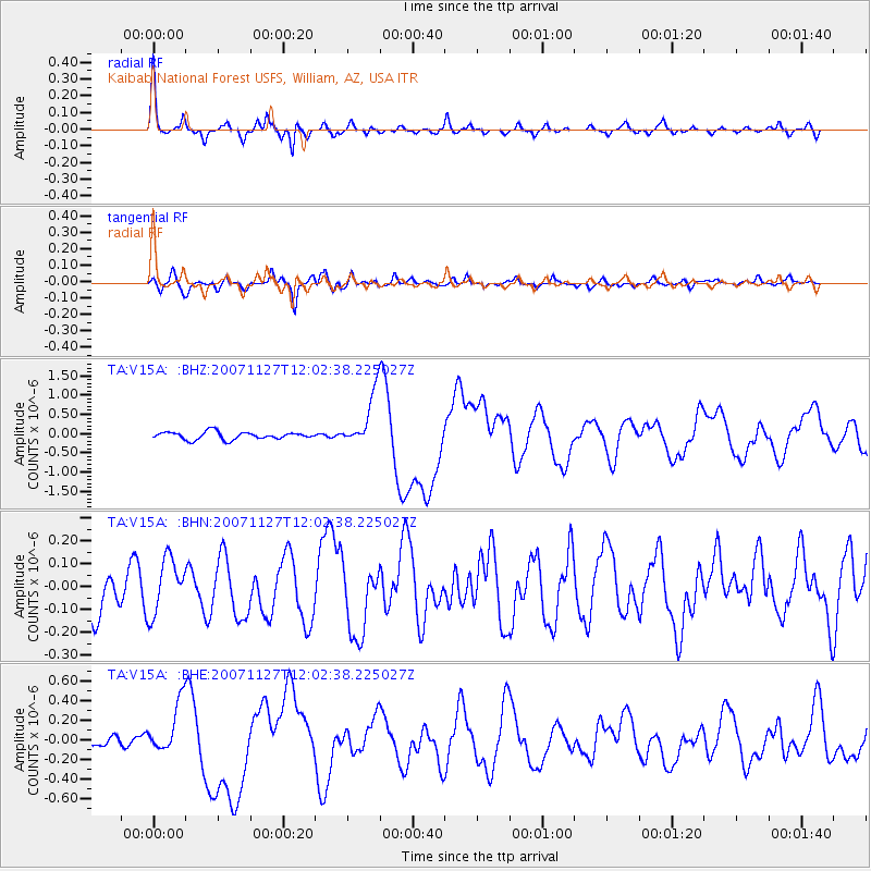
Signal To Noise
| Channel | StoN | STA | LTA |
| TA:V15A: :BHN:20071127T12:02:38.225027Z | 1.0194823 | 1.2010726E-7 | 1.17812014E-7 |
| TA:V15A: :BHE:20071127T12:02:38.225027Z | 2.6761842 | 2.4964416E-7 | 9.3283624E-8 |
| TA:V15A: :BHZ:20071127T12:02:38.225027Z | 7.263655 | 7.059378E-7 | 9.718769E-8 |
| Arrivals |
| Ps | 4.7 SECOND |
| PpPs | 17 SECOND |
| PsPs/PpSs | 21 SECOND |


