You are here: Home > Network List > TA - USArray Transportable Network (new EarthScope stations) Stations List
> Station V15A Kaibab National Forest USFS, William, AZ, USA > Earthquake Result Viewer
V15A Kaibab National Forest USFS, William, AZ, USA - Earthquake Result Viewer
| Earthquake location: |
Chile-Bolivia Border Region |
| Earthquake latitude/longitude: |
-21.3/-68.4 |
| Earthquake time(UTC): |
2007/05/01 (121) 03:52:21 GMT |
| Earthquake Depth: |
120 km |
| Earthquake Magnitude: |
5.5 MW, 5.4 MB |
| Earthquake Catalog/Contributor: |
WHDF/NEIC |
|
| Network: |
TA USArray Transportable Network (new EarthScope stations) |
| Station: |
V15A Kaibab National Forest USFS, William, AZ, USA |
| Lat/Lon: |
35.82 N/112.17 W |
| Elevation: |
1891 m |
|
| Distance: |
70.3 deg |
| Az: |
323.348 deg |
| Baz: |
136.779 deg |
| Ray Param: |
0.05474273 |
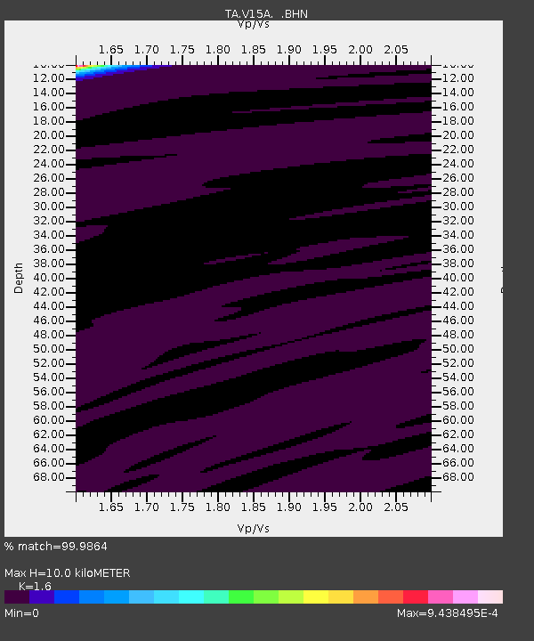
| Estimated Moho Depth: |
10.0 km |
| Estimated Crust Vp/Vs: |
1.60 |
| Assumed Crust Vp: |
6.276 km/s |
| Estimated Crust Vs: |
3.922 km/s |
| Estimated Crust Poisson's Ratio: |
0.18 |
|
| Radial Match: |
99.9864 % |
| Radial Bump: |
2 |
| Transverse Match: |
99.98283 % |
| Transverse Bump: |
2 |
| SOD ConfigId: |
2564 |
| Insert Time: |
2010-03-05 23:34:19.825 +0000 |
| GWidth: |
2.5 |
| Max Bumps: |
400 |
| Tol: |
0.001 |
|

Signal To Noise
| Channel | StoN | STA | LTA |
| TA:V15A: :BHN:20070501T04:02:50.773022Z | 0.7291637 | 6.600846E-8 | 9.052626E-8 |
| TA:V15A: :BHE:20070501T04:02:50.773022Z | 0.8866446 | 7.3735845E-7 | 8.316279E-7 |
| TA:V15A: :BHZ:20070501T04:02:50.773022Z | 0.94686943 | 5.395821E-7 | 5.698591E-7 |
| Arrivals |
| Ps | 1.0 SECOND |
| PpPs | 4.0 SECOND |
| PsPs/PpSs | 5.0 SECOND |


