You are here: Home > Network List > TA - USArray Transportable Network (new EarthScope stations) Stations List
> Station D25K Kavik River, AK, USA > Earthquake Result Viewer
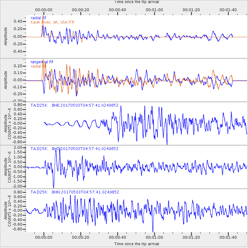
D25K Kavik River, AK, USA - Earthquake Result Viewer
*The percent match for this event was below the threshold and hence no stack was calculated.
| Earthquake location: |
Tajikistan |
| Earthquake latitude/longitude: |
39.5/71.4 |
| Earthquake time(UTC): |
2017/05/03 (123) 04:47:13 GMT |
| Earthquake Depth: |
10 km |
| Earthquake Magnitude: |
5.9 Mww |
| Earthquake Catalog/Contributor: |
NEIC PDE/us |
|
| Network: |
TA USArray Transportable Network (new EarthScope stations) |
| Station: |
D25K Kavik River, AK, USA |
| Lat/Lon: |
69.32 N/146.38 W |
| Elevation: |
770 m |
|
| Distance: |
68.0 deg |
| Az: |
13.576 deg |
| Baz: |
329.253 deg |
| Ray Param: |
$rayparam |
*The percent match for this event was below the threshold and hence was not used in the summary stack. |
|
| Radial Match: |
72.45786 % |
| Radial Bump: |
400 |
| Transverse Match: |
73.647606 % |
| Transverse Bump: |
400 |
| SOD ConfigId: |
11737051 |
| Insert Time: |
2019-04-27 06:49:39.428 +0000 |
| GWidth: |
2.5 |
| Max Bumps: |
400 |
| Tol: |
0.001 |
|
Signal To Noise
| Channel | StoN | STA | LTA |
| TA:D25K: :BHZ:20170503T04:57:41.024985Z | 3.9637444 | 3.2518463E-7 | 8.203976E-8 |
| TA:D25K: :BHN:20170503T04:57:41.024985Z | 1.1141466 | 1.49519E-7 | 1.3420048E-7 |
| TA:D25K: :BHE:20170503T04:57:41.024985Z | 1.619358 | 1.2351632E-7 | 7.6274866E-8 |
| Arrivals |
| Ps | |
| PpPs | |
| PsPs/PpSs | |


