You are here: Home > Network List > TA - USArray Transportable Network (new EarthScope stations) Stations List
> Station V15A Kaibab National Forest USFS, William, AZ, USA > Earthquake Result Viewer
V15A Kaibab National Forest USFS, William, AZ, USA - Earthquake Result Viewer

| Earthquake location: |
Iceland |
| Earthquake latitude/longitude: |
64.0/-21.0 |
| Earthquake time(UTC): |
2008/05/29 (150) 15:46:00 GMT |
| Earthquake Depth: |
10 km |
| Earthquake Magnitude: |
6.0 MB, 6.2 MS, 6.3 MW, 6.2 MW |
| Earthquake Catalog/Contributor: |
WHDF/NEIC |
|
| Network: |
TA USArray Transportable Network (new EarthScope stations) |
| Station: |
V15A Kaibab National Forest USFS, William, AZ, USA |
| Lat/Lon: |
35.82 N/112.17 W |
| Elevation: |
1891 m |
|
| Distance: |
59.0 deg |
| Az: |
288.479 deg |
| Baz: |
30.949 deg |
| Ray Param: |
0.062509425 |
| Estimated Moho Depth: |
21.75 km |
| Estimated Crust Vp/Vs: |
1.96 |
| Assumed Crust Vp: |
6.276 km/s |
| Estimated Crust Vs: |
3.21 km/s |
| Estimated Crust Poisson's Ratio: |
0.32 |
|
| Radial Match: |
88.91024 % |
| Radial Bump: |
350 |
| Transverse Match: |
74.46549 % |
| Transverse Bump: |
400 |
| SOD ConfigId: |
2504 |
| Insert Time: |
2010-03-05 23:34:31.854 +0000 |
| GWidth: |
2.5 |
| Max Bumps: |
400 |
| Tol: |
0.001 |
|
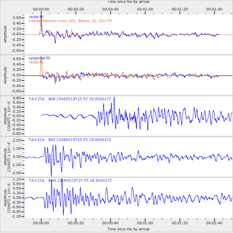
Signal To Noise
| Channel | StoN | STA | LTA |
| TA:V15A: :BHZ:20080529T15:55:28.800017Z | 4.942688 | 5.376765E-7 | 1.08782196E-7 |
| TA:V15A: :BHN:20080529T15:55:28.800017Z | 3.349026 | 2.636668E-7 | 7.87294E-8 |
| TA:V15A: :BHE:20080529T15:55:28.800017Z | 2.9074457 | 1.6593336E-7 | 5.707187E-8 |
| Arrivals |
| Ps | 3.4 SECOND |
| PpPs | 9.8 SECOND |
| PsPs/PpSs | 13 SECOND |


