You are here: Home > Network List > AV - Alaska Volcano Observatory Stations List
> Station SPCR Ckakachatna River, Mount Spurr, Alaska > Earthquake Result Viewer
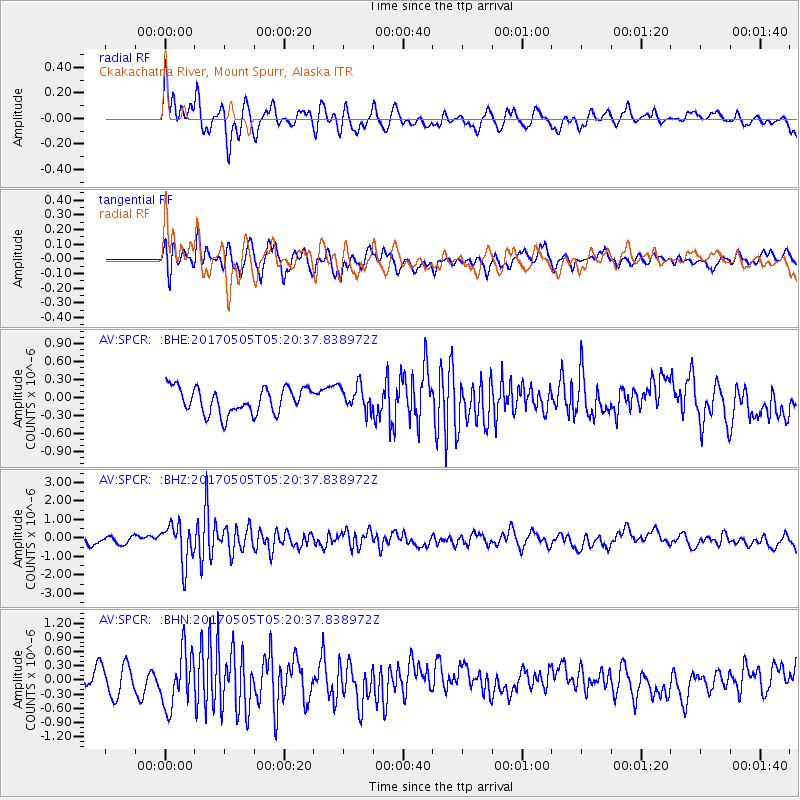
SPCR Ckakachatna River, Mount Spurr, Alaska - Earthquake Result Viewer
*The percent match for this event was below the threshold and hence no stack was calculated.
| Earthquake location: |
Tajikistan |
| Earthquake latitude/longitude: |
39.5/71.4 |
| Earthquake time(UTC): |
2017/05/05 (125) 05:09:35 GMT |
| Earthquake Depth: |
10 km |
| Earthquake Magnitude: |
5.8 Mww |
| Earthquake Catalog/Contributor: |
NEIC PDE/us |
|
| Network: |
AV Alaska Volcano Observatory |
| Station: |
SPCR Ckakachatna River, Mount Spurr, Alaska |
| Lat/Lon: |
61.20 N/152.21 W |
| Elevation: |
984 m |
|
| Distance: |
73.6 deg |
| Az: |
20.395 deg |
| Baz: |
326.15 deg |
| Ray Param: |
$rayparam |
*The percent match for this event was below the threshold and hence was not used in the summary stack. |
|
| Radial Match: |
66.15328 % |
| Radial Bump: |
400 |
| Transverse Match: |
61.336475 % |
| Transverse Bump: |
400 |
| SOD ConfigId: |
11737051 |
| Insert Time: |
2019-04-27 06:53:43.850 +0000 |
| GWidth: |
2.5 |
| Max Bumps: |
400 |
| Tol: |
0.001 |
|
Signal To Noise
| Channel | StoN | STA | LTA |
| AV:SPCR: :BHZ:20170505T05:20:37.838972Z | 4.692229 | 1.038755E-6 | 2.2137776E-7 |
| AV:SPCR: :BHN:20170505T05:20:37.838972Z | 2.0169983 | 5.7728E-7 | 2.8620747E-7 |
| AV:SPCR: :BHE:20170505T05:20:37.838972Z | 0.989451 | 2.1200228E-7 | 2.1426254E-7 |
| Arrivals |
| Ps | |
| PpPs | |
| PsPs/PpSs | |


