You are here: Home > Network List > TA - USArray Transportable Network (new EarthScope stations) Stations List
> Station V15A Kaibab National Forest USFS, William, AZ, USA > Earthquake Result Viewer
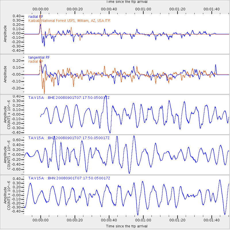
V15A Kaibab National Forest USFS, William, AZ, USA - Earthquake Result Viewer
*The percent match for this event was below the threshold and hence no stack was calculated.
| Earthquake location: |
Fiji Islands Region |
| Earthquake latitude/longitude: |
-15.3/-176.4 |
| Earthquake time(UTC): |
2008/09/01 (245) 07:06:16 GMT |
| Earthquake Depth: |
10 km |
| Earthquake Magnitude: |
5.6 MS, 5.4 MB, 5.7 MW, 5.7 MW |
| Earthquake Catalog/Contributor: |
WHDF/NEIC |
|
| Network: |
TA USArray Transportable Network (new EarthScope stations) |
| Station: |
V15A Kaibab National Forest USFS, William, AZ, USA |
| Lat/Lon: |
35.82 N/112.17 W |
| Elevation: |
1891 m |
|
| Distance: |
79.1 deg |
| Az: |
48.187 deg |
| Baz: |
242.268 deg |
| Ray Param: |
$rayparam |
*The percent match for this event was below the threshold and hence was not used in the summary stack. |
|
| Radial Match: |
71.81271 % |
| Radial Bump: |
400 |
| Transverse Match: |
40.30242 % |
| Transverse Bump: |
354 |
| SOD ConfigId: |
2504 |
| Insert Time: |
2010-03-05 23:35:16.088 +0000 |
| GWidth: |
2.5 |
| Max Bumps: |
400 |
| Tol: |
0.001 |
|
Signal To Noise
| Channel | StoN | STA | LTA |
| TA:V15A: :BHZ:20080901T07:17:50.050017Z | 2.2715065 | 2.4275616E-7 | 1.06870104E-7 |
| TA:V15A: :BHN:20080901T07:17:50.050017Z | 0.8422438 | 1.1032532E-7 | 1.3098976E-7 |
| TA:V15A: :BHE:20080901T07:17:50.050017Z | 0.94473845 | 1.3741595E-7 | 1.4545397E-7 |
| Arrivals |
| Ps | |
| PpPs | |
| PsPs/PpSs | |


