You are here: Home > Network List > TA - USArray Transportable Network (new EarthScope stations) Stations List
> Station V15A Kaibab National Forest USFS, William, AZ, USA > Earthquake Result Viewer
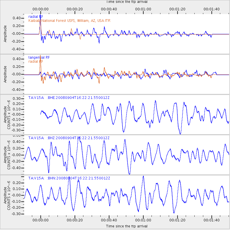
V15A Kaibab National Forest USFS, William, AZ, USA - Earthquake Result Viewer
*The percent match for this event was below the threshold and hence no stack was calculated.
| Earthquake location: |
Kermadec Islands Region |
| Earthquake latitude/longitude: |
-31.6/-177.8 |
| Earthquake time(UTC): |
2008/09/04 (248) 16:09:51 GMT |
| Earthquake Depth: |
26 km |
| Earthquake Magnitude: |
5.5 MB, 5.9 MS, 5.8 MW, 5.7 MW |
| Earthquake Catalog/Contributor: |
WHDF/NEIC |
|
| Network: |
TA USArray Transportable Network (new EarthScope stations) |
| Station: |
V15A Kaibab National Forest USFS, William, AZ, USA |
| Lat/Lon: |
35.82 N/112.17 W |
| Elevation: |
1891 m |
|
| Distance: |
91.0 deg |
| Az: |
47.769 deg |
| Baz: |
231.057 deg |
| Ray Param: |
$rayparam |
*The percent match for this event was below the threshold and hence was not used in the summary stack. |
|
| Radial Match: |
74.89026 % |
| Radial Bump: |
400 |
| Transverse Match: |
61.22758 % |
| Transverse Bump: |
400 |
| SOD ConfigId: |
2504 |
| Insert Time: |
2010-03-05 23:35:40.413 +0000 |
| GWidth: |
2.5 |
| Max Bumps: |
400 |
| Tol: |
0.001 |
|
Signal To Noise
| Channel | StoN | STA | LTA |
| TA:V15A: :BHZ:20080904T16:22:21.550012Z | 1.7432361 | 1.9283671E-7 | 1.10619965E-7 |
| TA:V15A: :BHN:20080904T16:22:21.550012Z | 1.5043324 | 1.0660496E-7 | 7.086529E-8 |
| TA:V15A: :BHE:20080904T16:22:21.550012Z | 1.6992049 | 1.2031924E-7 | 7.080914E-8 |
| Arrivals |
| Ps | |
| PpPs | |
| PsPs/PpSs | |


