You are here: Home > Network List > TA - USArray Transportable Network (new EarthScope stations) Stations List
> Station 531A Rocksprings, TX, USA > Earthquake Result Viewer
531A Rocksprings, TX, USA - Earthquake Result Viewer
| Earthquake location: |
Samoa Islands Region |
| Earthquake latitude/longitude: |
-15.2/-172.6 |
| Earthquake time(UTC): |
2009/08/30 (242) 14:51:32 GMT |
| Earthquake Depth: |
11 km |
| Earthquake Magnitude: |
6.4 MB, 6.3 MS, 6.6 MW, 6.6 MW |
| Earthquake Catalog/Contributor: |
WHDF/NEIC |
|
| Network: |
TA USArray Transportable Network (new EarthScope stations) |
| Station: |
531A Rocksprings, TX, USA |
| Lat/Lon: |
30.16 N/100.55 W |
| Elevation: |
661 m |
|
| Distance: |
82.7 deg |
| Az: |
56.156 deg |
| Baz: |
247.789 deg |
| Ray Param: |
0.046723064 |
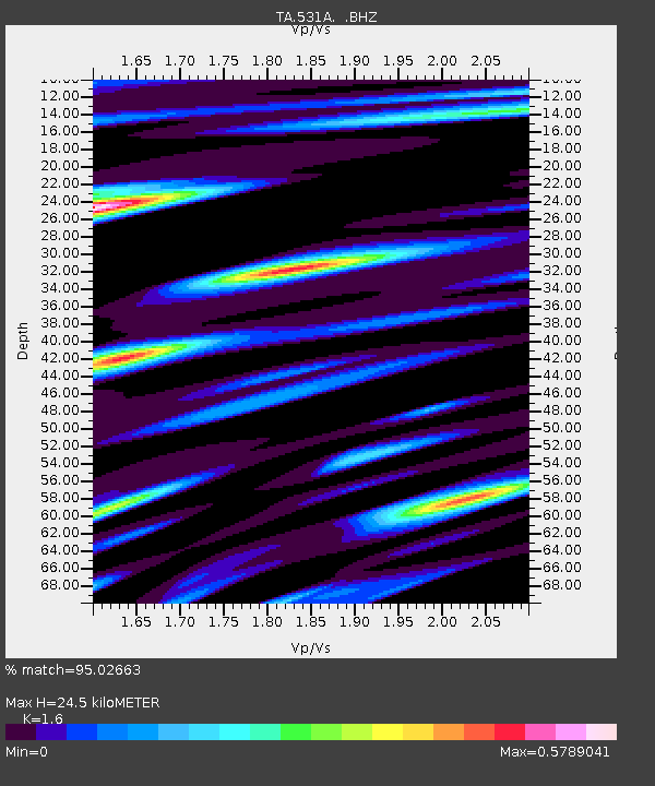
| Estimated Moho Depth: |
24.5 km |
| Estimated Crust Vp/Vs: |
1.60 |
| Assumed Crust Vp: |
6.38 km/s |
| Estimated Crust Vs: |
3.988 km/s |
| Estimated Crust Poisson's Ratio: |
0.18 |
|
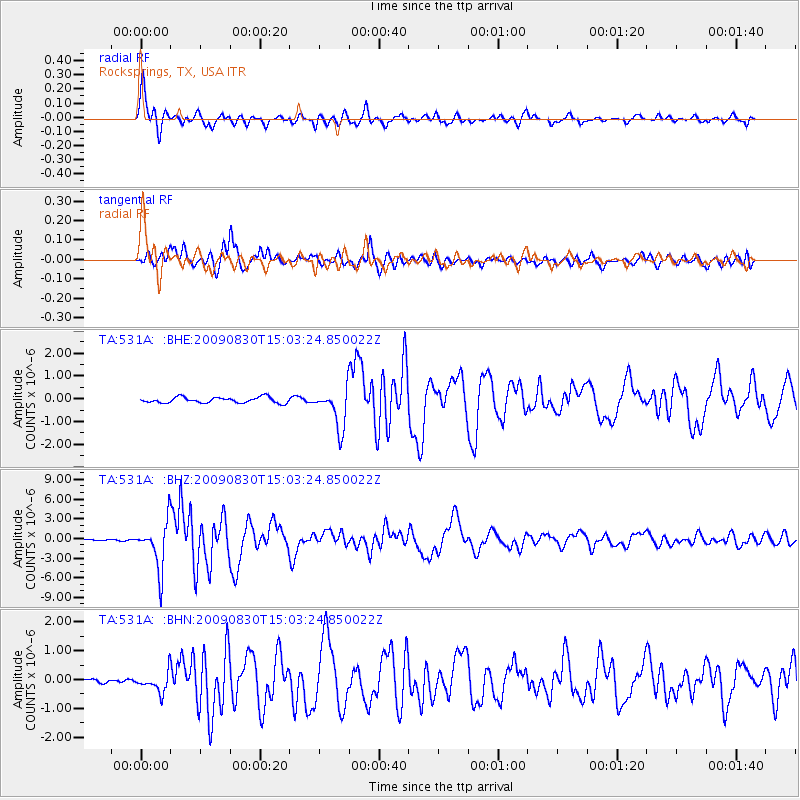
| Radial Match: |
95.02663 % |
| Radial Bump: |
400 |
| Transverse Match: |
92.38094 % |
| Transverse Bump: |
400 |
| SOD ConfigId: |
2622 |
| Insert Time: |
2010-03-05 23:35:54.196 +0000 |
| GWidth: |
2.5 |
| Max Bumps: |
400 |
| Tol: |
0.001 |
|
Signal To Noise
| Channel | StoN | STA | LTA |
| TA:531A: :BHZ:20090830T15:03:24.850022Z | 32.96203 | 3.6261217E-6 | 1.1000906E-7 |
| TA:531A: :BHN:20090830T15:03:24.850022Z | 4.2902994 | 3.45806E-7 | 8.0601836E-8 |
| TA:531A: :BHE:20090830T15:03:24.850022Z | 7.107012 | 8.7935297E-7 | 1.2373033E-7 |
| Arrivals |
| Ps | 2.4 SECOND |
| PpPs | 9.7 SECOND |
| PsPs/PpSs | 12 SECOND |


