You are here: Home > Network List > TA - USArray Transportable Network (new EarthScope stations) Stations List
> Station 531A Rocksprings, TX, USA > Earthquake Result Viewer
531A Rocksprings, TX, USA - Earthquake Result Viewer

| Earthquake location: |
Tonga Islands |
| Earthquake latitude/longitude: |
-16.3/-173.5 |
| Earthquake time(UTC): |
2009/10/02 (275) 01:07:39 GMT |
| Earthquake Depth: |
8.0 km |
| Earthquake Magnitude: |
6.1 MB, 6.0 MS, 6.1 MW, 6.1 MW |
| Earthquake Catalog/Contributor: |
WHDF/NEIC |
|
| Network: |
TA USArray Transportable Network (new EarthScope stations) |
| Station: |
531A Rocksprings, TX, USA |
| Lat/Lon: |
30.16 N/100.55 W |
| Elevation: |
661 m |
|
| Distance: |
84.0 deg |
| Az: |
56.348 deg |
| Baz: |
247.348 deg |
| Ray Param: |
0.045786526 |
| Estimated Moho Depth: |
24.25 km |
| Estimated Crust Vp/Vs: |
1.60 |
| Assumed Crust Vp: |
6.38 km/s |
| Estimated Crust Vs: |
3.988 km/s |
| Estimated Crust Poisson's Ratio: |
0.18 |
|
| Radial Match: |
81.06948 % |
| Radial Bump: |
400 |
| Transverse Match: |
81.318695 % |
| Transverse Bump: |
323 |
| SOD ConfigId: |
2622 |
| Insert Time: |
2010-03-05 23:35:59.189 +0000 |
| GWidth: |
2.5 |
| Max Bumps: |
400 |
| Tol: |
0.001 |
|
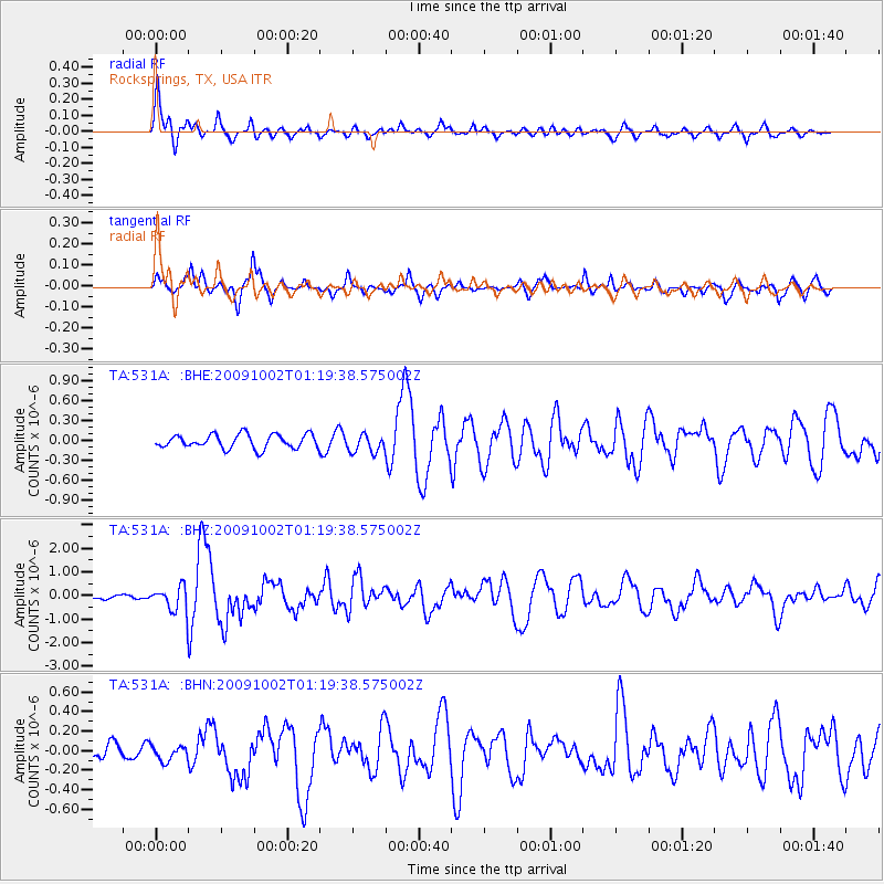
Signal To Noise
| Channel | StoN | STA | LTA |
| TA:531A: :BHZ:20091002T01:19:38.575002Z | 4.0121765 | 5.287618E-7 | 1.3178925E-7 |
| TA:531A: :BHN:20091002T01:19:38.575002Z | 0.46729586 | 7.48454E-8 | 1.6016706E-7 |
| TA:531A: :BHE:20091002T01:19:38.575002Z | 1.3097303 | 1.389619E-7 | 1.0609963E-7 |
| Arrivals |
| Ps | 2.3 SECOND |
| PpPs | 9.6 SECOND |
| PsPs/PpSs | 12 SECOND |


