You are here: Home > Network List > TA - USArray Transportable Network (new EarthScope stations) Stations List
> Station 531A Rocksprings, TX, USA > Earthquake Result Viewer
531A Rocksprings, TX, USA - Earthquake Result Viewer
| Earthquake location: |
Kuril Islands |
| Earthquake latitude/longitude: |
46.0/151.4 |
| Earthquake time(UTC): |
2009/04/18 (108) 19:17:58 GMT |
| Earthquake Depth: |
35 km |
| Earthquake Magnitude: |
6.3 MB, 6.3 MS, 6.6 MW, 6.4 MW |
| Earthquake Catalog/Contributor: |
WHDF/NEIC |
|
| Network: |
TA USArray Transportable Network (new EarthScope stations) |
| Station: |
531A Rocksprings, TX, USA |
| Lat/Lon: |
30.16 N/100.55 W |
| Elevation: |
661 m |
|
| Distance: |
80.1 deg |
| Az: |
56.716 deg |
| Baz: |
317.726 deg |
| Ray Param: |
0.048453365 |
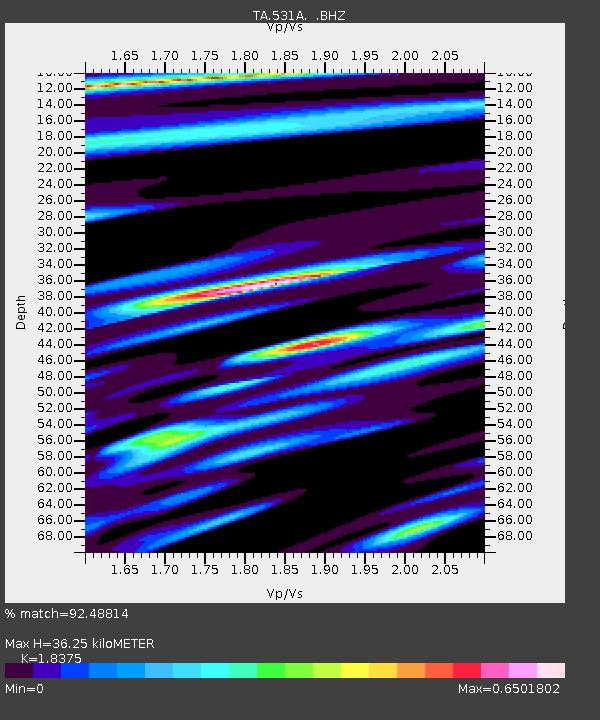
| Estimated Moho Depth: |
36.25 km |
| Estimated Crust Vp/Vs: |
1.84 |
| Assumed Crust Vp: |
6.38 km/s |
| Estimated Crust Vs: |
3.472 km/s |
| Estimated Crust Poisson's Ratio: |
0.29 |
|
| Radial Match: |
92.48814 % |
| Radial Bump: |
400 |
| Transverse Match: |
77.32055 % |
| Transverse Bump: |
400 |
| SOD ConfigId: |
2658 |
| Insert Time: |
2010-03-05 23:36:00.104 +0000 |
| GWidth: |
2.5 |
| Max Bumps: |
400 |
| Tol: |
0.001 |
|

Signal To Noise
| Channel | StoN | STA | LTA |
| TA:531A: :BHZ:20090418T19:29:34.20002Z | 15.491468 | 2.2214936E-6 | 1.4340111E-7 |
| TA:531A: :BHN:20090418T19:29:34.20002Z | 4.224671 | 6.257611E-7 | 1.4812068E-7 |
| TA:531A: :BHE:20090418T19:29:34.20002Z | 3.1952953 | 4.293701E-7 | 1.3437571E-7 |
| Arrivals |
| Ps | 4.9 SECOND |
| PpPs | 16 SECOND |
| PsPs/PpSs | 21 SECOND |


