You are here: Home > Network List > TA - USArray Transportable Network (new EarthScope stations) Stations List
> Station C27K Jago River, AK, USA > Earthquake Result Viewer
C27K Jago River, AK, USA - Earthquake Result Viewer
| Earthquake location: |
Tajikistan |
| Earthquake latitude/longitude: |
39.5/71.4 |
| Earthquake time(UTC): |
2017/05/05 (125) 05:09:35 GMT |
| Earthquake Depth: |
10 km |
| Earthquake Magnitude: |
5.8 Mww |
| Earthquake Catalog/Contributor: |
NEIC PDE/us |
|
| Network: |
TA USArray Transportable Network (new EarthScope stations) |
| Station: |
C27K Jago River, AK, USA |
| Lat/Lon: |
69.63 N/143.71 W |
| Elevation: |
392 m |
|
| Distance: |
68.2 deg |
| Az: |
12.544 deg |
| Baz: |
331.314 deg |
| Ray Param: |
0.05646409 |
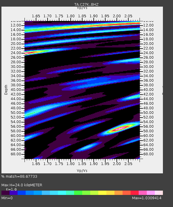
| Estimated Moho Depth: |
24.0 km |
| Estimated Crust Vp/Vs: |
1.60 |
| Assumed Crust Vp: |
6.522 km/s |
| Estimated Crust Vs: |
4.076 km/s |
| Estimated Crust Poisson's Ratio: |
0.18 |
|
| Radial Match: |
88.67733 % |
| Radial Bump: |
400 |
| Transverse Match: |
78.536125 % |
| Transverse Bump: |
400 |
| SOD ConfigId: |
11737051 |
| Insert Time: |
2019-04-27 06:59:02.887 +0000 |
| GWidth: |
2.5 |
| Max Bumps: |
400 |
| Tol: |
0.001 |
|

Signal To Noise
| Channel | StoN | STA | LTA |
| TA:C27K: :BHZ:20170505T05:20:05.22502Z | 14.204948 | 1.4025587E-6 | 9.873733E-8 |
| TA:C27K: :BHN:20170505T05:20:05.22502Z | 5.883354 | 3.1434118E-7 | 5.3428906E-8 |
| TA:C27K: :BHE:20170505T05:20:05.22502Z | 2.5682468 | 2.0844145E-7 | 8.1160984E-8 |
| Arrivals |
| Ps | 2.3 SECOND |
| PpPs | 9.2 SECOND |
| PsPs/PpSs | 11 SECOND |


