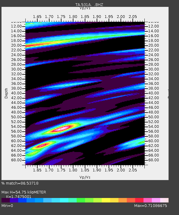
531A Rocksprings, TX, USA - Earthquake Result Viewer

Earthquake location: Rat Islands, Aleutian Islands
Earthquake latitude/longitude: 50.4/177.0
Earthquake time(UTC): 2009/07/06 (187) 14:53:12 GMT
Earthquake Depth: 22 km
Earthquake Magnitude: 6.0 MB, 5.8 MS, 6.1 MW, 6.0 MW
Earthquake Catalog/Contributor: WHDF/NEIC
Network: TA USArray Transportable Network (new EarthScope stations)
Station: 531A Rocksprings, TX, USA
Lat/Lon: 30.16 N/100.55 W
Elevation: 661 m
Distance: 62.8 deg
Az: 74.855 deg
Baz: 314.54 deg
Ray Param: 0.059960514
Estimated Moho Depth: 54.75 km
Estimated Crust Vp/Vs: 1.75
Assumed Crust Vp: 6.38 km/s
Estimated Crust Vs: 3.651 km/s
Estimated Crust Poisson's Ratio: 0.26
Radial Match: 86.53718 %
Radial Bump: 400
Transverse Match: 69.582794 %
Transverse Bump: 400
SOD ConfigId: 2648
Insert Time: 2010-03-05 23:36:05.122 +0000
GWidth: 2.5
Max Bumps: 400
Tol: 0.001

Signal To Noise

ChannelStoNSTALTA
TA:531A: :BHZ:20090706T15:03:04.974009Z9.4221211.8933085E-62.0094292E-7
TA:531A: :BHN:20090706T15:03:04.974009Z4.2600545.526012E-71.2971694E-7
TA:531A: :BHE:20090706T15:03:04.974009Z3.2770045.302501E-71.6180941E-7
Arrivals
Ps6.7 SECOND
PpPs23 SECOND
PsPs/PpSs29 SECOND