You are here: Home > Network List > TA - USArray Transportable Network (new EarthScope stations) Stations List
> Station F21K Alatna River, AK, USA > Earthquake Result Viewer
F21K Alatna River, AK, USA - Earthquake Result Viewer
| Earthquake location: |
Tajikistan |
| Earthquake latitude/longitude: |
39.5/71.4 |
| Earthquake time(UTC): |
2017/05/05 (125) 05:09:35 GMT |
| Earthquake Depth: |
10 km |
| Earthquake Magnitude: |
5.8 Mww |
| Earthquake Catalog/Contributor: |
NEIC PDE/us |
|
| Network: |
TA USArray Transportable Network (new EarthScope stations) |
| Station: |
F21K Alatna River, AK, USA |
| Lat/Lon: |
67.22 N/153.48 W |
| Elevation: |
597 m |
|
| Distance: |
68.3 deg |
| Az: |
17.215 deg |
| Baz: |
323.963 deg |
| Ray Param: |
0.056398153 |
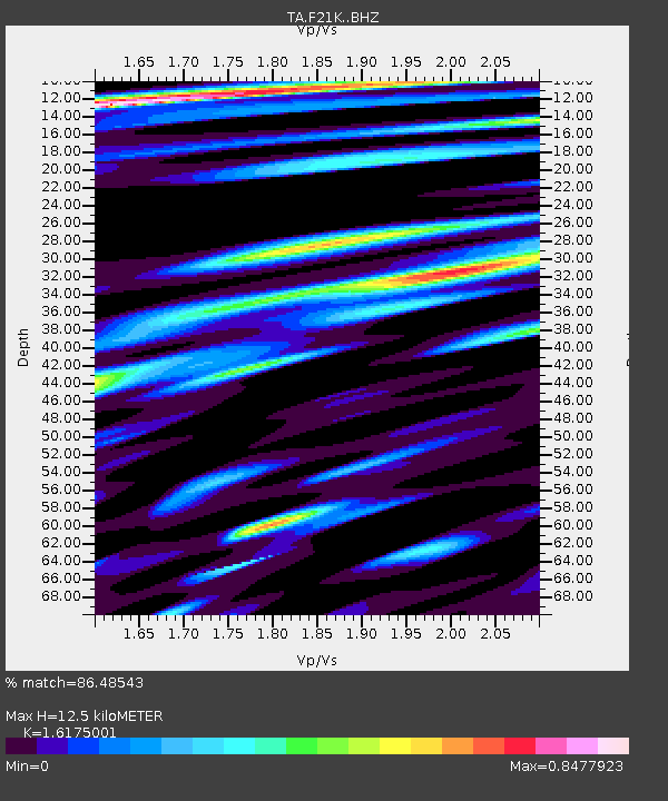
| Estimated Moho Depth: |
12.5 km |
| Estimated Crust Vp/Vs: |
1.62 |
| Assumed Crust Vp: |
6.455 km/s |
| Estimated Crust Vs: |
3.991 km/s |
| Estimated Crust Poisson's Ratio: |
0.19 |
|
| Radial Match: |
86.48543 % |
| Radial Bump: |
400 |
| Transverse Match: |
86.87244 % |
| Transverse Bump: |
400 |
| SOD ConfigId: |
11737051 |
| Insert Time: |
2019-04-27 06:59:13.647 +0000 |
| GWidth: |
2.5 |
| Max Bumps: |
400 |
| Tol: |
0.001 |
|
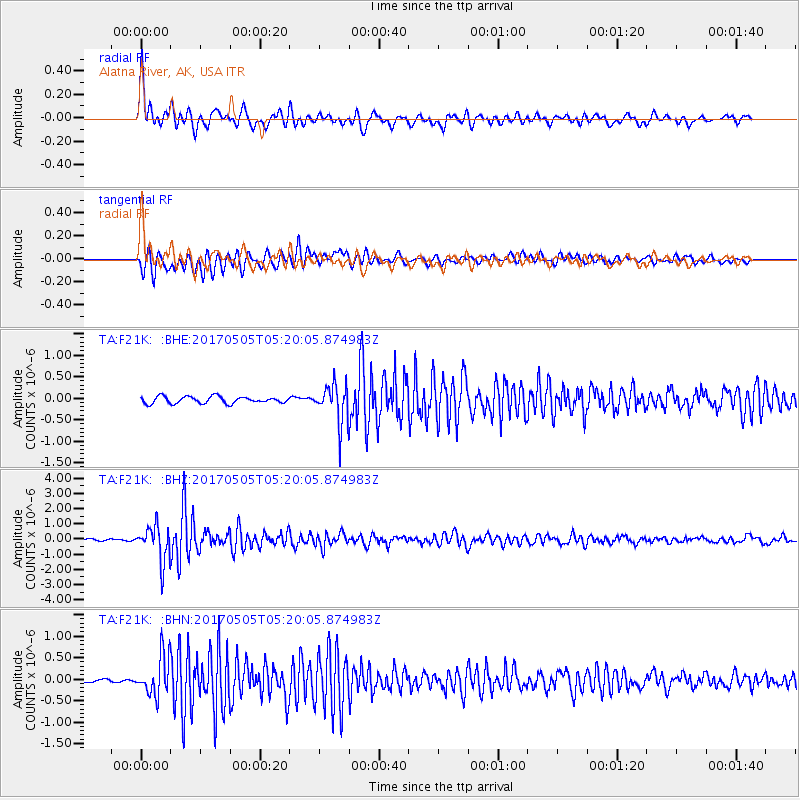
Signal To Noise
| Channel | StoN | STA | LTA |
| TA:F21K: :BHZ:20170505T05:20:05.874983Z | 13.7845745 | 1.179601E-6 | 8.557399E-8 |
| TA:F21K: :BHN:20170505T05:20:05.874983Z | 11.148794 | 4.6403554E-7 | 4.1622037E-8 |
| TA:F21K: :BHE:20170505T05:20:05.874983Z | 5.413784 | 4.304737E-7 | 7.951438E-8 |
| Arrivals |
| Ps | 1.2 SECOND |
| PpPs | 4.9 SECOND |
| PsPs/PpSs | 6.1 SECOND |


