You are here: Home > Network List > TA - USArray Transportable Network (new EarthScope stations) Stations List
> Station F22K John River, AK, USA > Earthquake Result Viewer
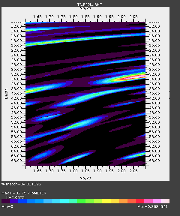
F22K John River, AK, USA - Earthquake Result Viewer
| Earthquake location: |
Tajikistan |
| Earthquake latitude/longitude: |
39.5/71.4 |
| Earthquake time(UTC): |
2017/05/05 (125) 05:09:35 GMT |
| Earthquake Depth: |
10 km |
| Earthquake Magnitude: |
5.8 Mww |
| Earthquake Catalog/Contributor: |
NEIC PDE/us |
|
| Network: |
TA USArray Transportable Network (new EarthScope stations) |
| Station: |
F22K John River, AK, USA |
| Lat/Lon: |
67.51 N/152.18 W |
| Elevation: |
546 m |
|
| Distance: |
68.4 deg |
| Az: |
16.594 deg |
| Baz: |
324.936 deg |
| Ray Param: |
0.056358833 |
| Estimated Moho Depth: |
32.75 km |
| Estimated Crust Vp/Vs: |
2.07 |
| Assumed Crust Vp: |
6.455 km/s |
| Estimated Crust Vs: |
3.122 km/s |
| Estimated Crust Poisson's Ratio: |
0.35 |
|
| Radial Match: |
84.811295 % |
| Radial Bump: |
400 |
| Transverse Match: |
87.1845 % |
| Transverse Bump: |
400 |
| SOD ConfigId: |
11737051 |
| Insert Time: |
2019-04-27 06:59:13.674 +0000 |
| GWidth: |
2.5 |
| Max Bumps: |
400 |
| Tol: |
0.001 |
|

Signal To Noise
| Channel | StoN | STA | LTA |
| TA:F22K: :BHZ:20170505T05:20:06.249983Z | 11.844415 | 1.2301145E-6 | 1.03856095E-7 |
| TA:F22K: :BHN:20170505T05:20:06.249983Z | 6.5409536 | 3.7579247E-7 | 5.7452247E-8 |
| TA:F22K: :BHE:20170505T05:20:06.249983Z | 5.903543 | 3.2642603E-7 | 5.529324E-8 |
| Arrivals |
| Ps | 5.6 SECOND |
| PpPs | 15 SECOND |
| PsPs/PpSs | 21 SECOND |


