You are here: Home > Network List > TA - USArray Transportable Network (new EarthScope stations) Stations List
> Station F26K Sheenjek River, AK, USA > Earthquake Result Viewer
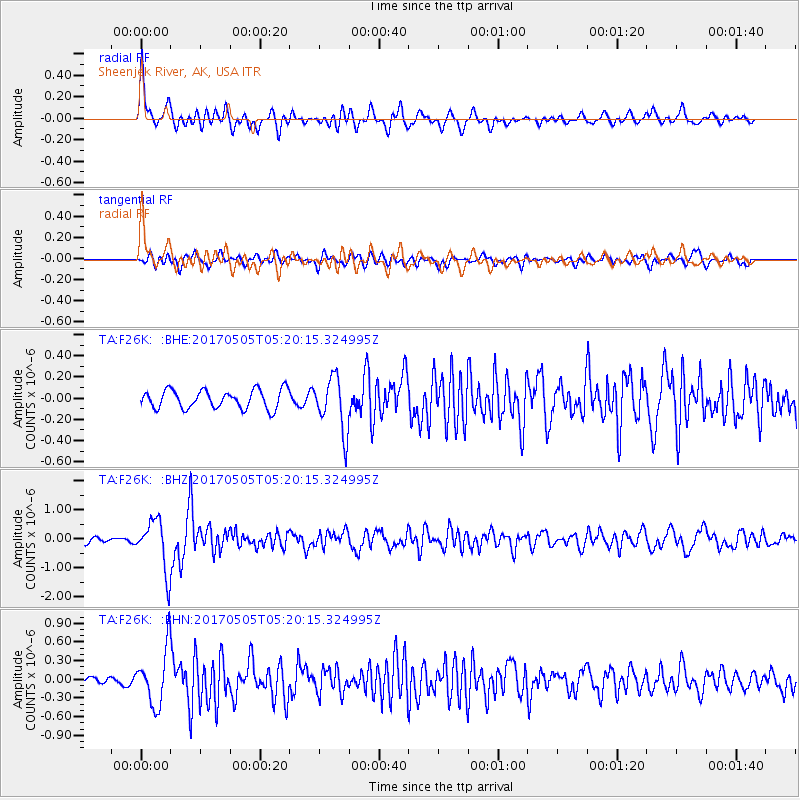
F26K Sheenjek River, AK, USA - Earthquake Result Viewer
*The percent match for this event was below the threshold and hence no stack was calculated.
| Earthquake location: |
Tajikistan |
| Earthquake latitude/longitude: |
39.5/71.4 |
| Earthquake time(UTC): |
2017/05/05 (125) 05:09:35 GMT |
| Earthquake Depth: |
10 km |
| Earthquake Magnitude: |
5.8 Mww |
| Earthquake Catalog/Contributor: |
NEIC PDE/us |
|
| Network: |
TA USArray Transportable Network (new EarthScope stations) |
| Station: |
F26K Sheenjek River, AK, USA |
| Lat/Lon: |
67.69 N/144.15 W |
| Elevation: |
683 m |
|
| Distance: |
69.8 deg |
| Az: |
13.691 deg |
| Baz: |
331.321 deg |
| Ray Param: |
$rayparam |
*The percent match for this event was below the threshold and hence was not used in the summary stack. |
|
| Radial Match: |
78.70443 % |
| Radial Bump: |
400 |
| Transverse Match: |
72.70933 % |
| Transverse Bump: |
400 |
| SOD ConfigId: |
11737051 |
| Insert Time: |
2019-04-27 06:59:14.744 +0000 |
| GWidth: |
2.5 |
| Max Bumps: |
400 |
| Tol: |
0.001 |
|
Signal To Noise
| Channel | StoN | STA | LTA |
| TA:F26K: :BHZ:20170505T05:20:15.324995Z | 7.349814 | 8.7838526E-7 | 1.1951123E-7 |
| TA:F26K: :BHN:20170505T05:20:15.324995Z | 8.3220005 | 4.4963295E-7 | 5.402943E-8 |
| TA:F26K: :BHE:20170505T05:20:15.324995Z | 2.8706696 | 2.5124035E-7 | 8.751977E-8 |
| Arrivals |
| Ps | |
| PpPs | |
| PsPs/PpSs | |


