You are here: Home > Network List > TA - USArray Transportable Network (new EarthScope stations) Stations List
> Station G21K Allakaket, AK, USA > Earthquake Result Viewer
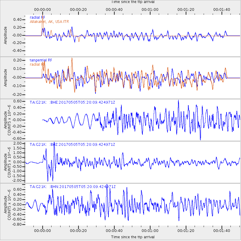
G21K Allakaket, AK, USA - Earthquake Result Viewer
*The percent match for this event was below the threshold and hence no stack was calculated.
| Earthquake location: |
Tajikistan |
| Earthquake latitude/longitude: |
39.5/71.4 |
| Earthquake time(UTC): |
2017/05/05 (125) 05:09:35 GMT |
| Earthquake Depth: |
10 km |
| Earthquake Magnitude: |
5.8 Mww |
| Earthquake Catalog/Contributor: |
NEIC PDE/us |
|
| Network: |
TA USArray Transportable Network (new EarthScope stations) |
| Station: |
G21K Allakaket, AK, USA |
| Lat/Lon: |
66.52 N/153.51 W |
| Elevation: |
446 m |
|
| Distance: |
68.9 deg |
| Az: |
17.671 deg |
| Baz: |
324.108 deg |
| Ray Param: |
$rayparam |
*The percent match for this event was below the threshold and hence was not used in the summary stack. |
|
| Radial Match: |
64.60454 % |
| Radial Bump: |
400 |
| Transverse Match: |
53.88602 % |
| Transverse Bump: |
400 |
| SOD ConfigId: |
11737051 |
| Insert Time: |
2019-04-27 06:59:17.275 +0000 |
| GWidth: |
2.5 |
| Max Bumps: |
400 |
| Tol: |
0.001 |
|
Signal To Noise
| Channel | StoN | STA | LTA |
| TA:G21K: :BHZ:20170505T05:20:09.424971Z | 14.386303 | 7.850265E-7 | 5.4567636E-8 |
| TA:G21K: :BHN:20170505T05:20:09.424971Z | 3.815337 | 1.9390882E-7 | 5.0823513E-8 |
| TA:G21K: :BHE:20170505T05:20:09.424971Z | 1.4931115 | 1.5338449E-7 | 1.02728094E-7 |
| Arrivals |
| Ps | |
| PpPs | |
| PsPs/PpSs | |


