You are here: Home > Network List > TA - USArray Transportable Network (new EarthScope stations) Stations List
> Station G27K Doyon Strip, AK, USA > Earthquake Result Viewer
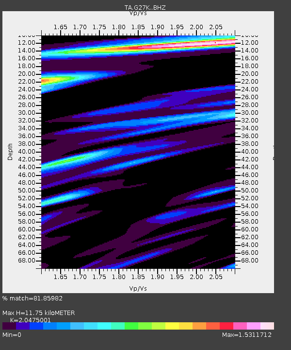
G27K Doyon Strip, AK, USA - Earthquake Result Viewer
| Earthquake location: |
Tajikistan |
| Earthquake latitude/longitude: |
39.5/71.4 |
| Earthquake time(UTC): |
2017/05/05 (125) 05:09:35 GMT |
| Earthquake Depth: |
10 km |
| Earthquake Magnitude: |
5.8 Mww |
| Earthquake Catalog/Contributor: |
NEIC PDE/us |
|
| Network: |
TA USArray Transportable Network (new EarthScope stations) |
| Station: |
G27K Doyon Strip, AK, USA |
| Lat/Lon: |
66.81 N/141.65 W |
| Elevation: |
686 m |
|
| Distance: |
71.1 deg |
| Az: |
13.218 deg |
| Baz: |
333.457 deg |
| Ray Param: |
0.05457259 |
| Estimated Moho Depth: |
11.75 km |
| Estimated Crust Vp/Vs: |
2.05 |
| Assumed Crust Vp: |
6.577 km/s |
| Estimated Crust Vs: |
3.212 km/s |
| Estimated Crust Poisson's Ratio: |
0.34 |
|
| Radial Match: |
81.85982 % |
| Radial Bump: |
400 |
| Transverse Match: |
87.43176 % |
| Transverse Bump: |
400 |
| SOD ConfigId: |
11737051 |
| Insert Time: |
2019-04-27 06:59:21.100 +0000 |
| GWidth: |
2.5 |
| Max Bumps: |
400 |
| Tol: |
0.001 |
|

Signal To Noise
| Channel | StoN | STA | LTA |
| TA:G27K: :BHZ:20170505T05:20:22.85002Z | 10.293738 | 1.0176883E-6 | 9.886478E-8 |
| TA:G27K: :BHN:20170505T05:20:22.85002Z | 3.8818026 | 4.1904224E-7 | 1.0795043E-7 |
| TA:G27K: :BHE:20170505T05:20:22.85002Z | 2.9529204 | 2.0381206E-7 | 6.902051E-8 |
| Arrivals |
| Ps | 1.9 SECOND |
| PpPs | 5.3 SECOND |
| PsPs/PpSs | 7.2 SECOND |


