You are here: Home > Network List > TA - USArray Transportable Network (new EarthScope stations) Stations List
> Station 531A Rocksprings, TX, USA > Earthquake Result Viewer
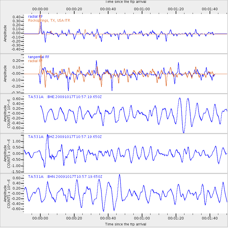
531A Rocksprings, TX, USA - Earthquake Result Viewer
*The percent match for this event was below the threshold and hence no stack was calculated.
| Earthquake location: |
Samoa Islands Region |
| Earthquake latitude/longitude: |
-16.4/-172.0 |
| Earthquake time(UTC): |
2009/10/17 (290) 10:45:26 GMT |
| Earthquake Depth: |
10 km |
| Earthquake Magnitude: |
5.7 MB, 5.3 MS, 5.7 MW, 5.7 MW |
| Earthquake Catalog/Contributor: |
WHDF/NEIC |
|
| Network: |
TA USArray Transportable Network (new EarthScope stations) |
| Station: |
531A Rocksprings, TX, USA |
| Lat/Lon: |
30.16 N/100.55 W |
| Elevation: |
661 m |
|
| Distance: |
82.8 deg |
| Az: |
55.838 deg |
| Baz: |
246.523 deg |
| Ray Param: |
$rayparam |
*The percent match for this event was below the threshold and hence was not used in the summary stack. |
|
| Radial Match: |
52.590637 % |
| Radial Bump: |
258 |
| Transverse Match: |
63.588078 % |
| Transverse Bump: |
323 |
| SOD ConfigId: |
2622 |
| Insert Time: |
2010-03-05 23:36:19.055 +0000 |
| GWidth: |
2.5 |
| Max Bumps: |
400 |
| Tol: |
0.001 |
|
Signal To Noise
| Channel | StoN | STA | LTA |
| TA:531A: :BHZ:20091017T10:57:19.650Z | 3.1262279 | 7.617847E-7 | 2.4367534E-7 |
| TA:531A: :BHN:20091017T10:57:19.650Z | 1.1774105 | 2.598395E-7 | 2.2068726E-7 |
| TA:531A: :BHE:20091017T10:57:19.650Z | 0.70361525 | 1.335336E-7 | 1.8978214E-7 |
| Arrivals |
| Ps | |
| PpPs | |
| PsPs/PpSs | |


