You are here: Home > Network List > TA - USArray Transportable Network (new EarthScope stations) Stations List
> Station 531A Rocksprings, TX, USA > Earthquake Result Viewer
531A Rocksprings, TX, USA - Earthquake Result Viewer
*The percent match for this event was below the threshold and hence no stack was calculated.
| Earthquake location: |
Kermadec Islands Region |
| Earthquake latitude/longitude: |
-31.5/-178.8 |
| Earthquake time(UTC): |
2009/05/16 (136) 00:53:52 GMT |
| Earthquake Depth: |
55 km |
| Earthquake Magnitude: |
6.1 MB, 6.5 MW, 6.3 MW |
| Earthquake Catalog/Contributor: |
WHDF/NEIC |
|
| Network: |
TA USArray Transportable Network (new EarthScope stations) |
| Station: |
531A Rocksprings, TX, USA |
| Lat/Lon: |
30.16 N/100.55 W |
| Elevation: |
661 m |
|
| Distance: |
96.3 deg |
| Az: |
58.54 deg |
| Baz: |
237.264 deg |
| Ray Param: |
$rayparam |
*The percent match for this event was below the threshold and hence was not used in the summary stack. |
|
| Radial Match: |
76.31942 % |
| Radial Bump: |
400 |
| Transverse Match: |
72.150154 % |
| Transverse Bump: |
349 |
| SOD ConfigId: |
2760 |
| Insert Time: |
2010-03-05 23:36:29.965 +0000 |
| GWidth: |
2.5 |
| Max Bumps: |
400 |
| Tol: |
0.001 |
|
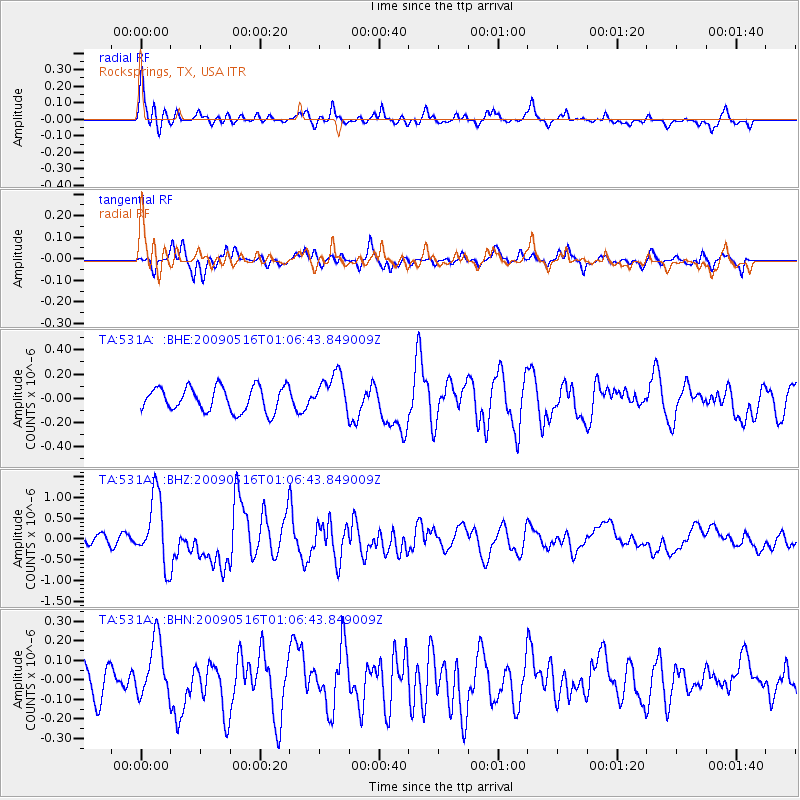
Signal To Noise
| Channel | StoN | STA | LTA |
| TA:531A: :BHZ:20090516T01:06:43.849009Z | 9.292588 | 8.196747E-7 | 8.8207365E-8 |
| TA:531A: :BHN:20090516T01:06:43.849009Z | 1.6595299 | 1.5099813E-7 | 9.09885E-8 |
| TA:531A: :BHE:20090516T01:06:43.849009Z | 1.6055686 | 1.6001876E-7 | 9.966485E-8 |
| Arrivals |
| Ps | |
| PpPs | |
| PsPs/PpSs | |


