You are here: Home > Network List > TA - USArray Transportable Network (new EarthScope stations) Stations List
> Station 432A Menard, TX, USA > Earthquake Result Viewer
432A Menard, TX, USA - Earthquake Result Viewer
| Earthquake location: |
Samoa Islands Region |
| Earthquake latitude/longitude: |
-15.5/-172.1 |
| Earthquake time(UTC): |
2009/09/29 (272) 17:48:10 GMT |
| Earthquake Depth: |
18 km |
| Earthquake Magnitude: |
7.1 MB, 8.1 MS, 8.1 MW, 8.0 MW |
| Earthquake Catalog/Contributor: |
WHDF/NEIC |
|
| Network: |
TA USArray Transportable Network (new EarthScope stations) |
| Station: |
432A Menard, TX, USA |
| Lat/Lon: |
30.88 N/99.79 W |
| Elevation: |
647 m |
|
| Distance: |
83.3 deg |
| Az: |
55.56 deg |
| Baz: |
247.639 deg |
| Ray Param: |
0.04626523 |
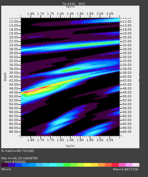
| Estimated Moho Depth: |
46.25 km |
| Estimated Crust Vp/Vs: |
1.67 |
| Assumed Crust Vp: |
6.498 km/s |
| Estimated Crust Vs: |
3.891 km/s |
| Estimated Crust Poisson's Ratio: |
0.22 |
|
| Radial Match: |
98.701065 % |
| Radial Bump: |
400 |
| Transverse Match: |
90.61062 % |
| Transverse Bump: |
400 |
| SOD ConfigId: |
2622 |
| Insert Time: |
2010-03-05 23:36:45.205 +0000 |
| GWidth: |
2.5 |
| Max Bumps: |
400 |
| Tol: |
0.001 |
|

Signal To Noise
| Channel | StoN | STA | LTA |
| TA:432A: :BHZ:20090929T18:00:05.174021Z | 17.143532 | 3.3454044E-6 | 1.951409E-7 |
| TA:432A: :BHN:20090929T18:00:05.174021Z | 6.710718 | 5.2992164E-7 | 7.896646E-8 |
| TA:432A: :BHE:20090929T18:00:05.174021Z | 8.0042925 | 1.0643042E-6 | 1.3296669E-7 |
| Arrivals |
| Ps | 4.9 SECOND |
| PpPs | 18 SECOND |
| PsPs/PpSs | 23 SECOND |


