You are here: Home > Network List > TA - USArray Transportable Network (new EarthScope stations) Stations List
> Station 432A Menard, TX, USA > Earthquake Result Viewer
432A Menard, TX, USA - Earthquake Result Viewer

| Earthquake location: |
Tonga Islands |
| Earthquake latitude/longitude: |
-15.4/-173.2 |
| Earthquake time(UTC): |
2009/09/29 (272) 18:40:09 GMT |
| Earthquake Depth: |
2.3 km |
| Earthquake Magnitude: |
5.5 MB |
| Earthquake Catalog/Contributor: |
WHDF/NEIC |
|
| Network: |
TA USArray Transportable Network (new EarthScope stations) |
| Station: |
432A Menard, TX, USA |
| Lat/Lon: |
30.88 N/99.79 W |
| Elevation: |
647 m |
|
| Distance: |
84.1 deg |
| Az: |
55.942 deg |
| Baz: |
248.372 deg |
| Ray Param: |
0.045698967 |
| Estimated Moho Depth: |
69.75 km |
| Estimated Crust Vp/Vs: |
2.02 |
| Assumed Crust Vp: |
6.498 km/s |
| Estimated Crust Vs: |
3.221 km/s |
| Estimated Crust Poisson's Ratio: |
0.34 |
|
| Radial Match: |
90.55238 % |
| Radial Bump: |
400 |
| Transverse Match: |
67.71123 % |
| Transverse Bump: |
400 |
| SOD ConfigId: |
2622 |
| Insert Time: |
2010-03-05 23:36:46.097 +0000 |
| GWidth: |
2.5 |
| Max Bumps: |
400 |
| Tol: |
0.001 |
|
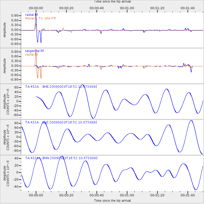
Signal To Noise
| Channel | StoN | STA | LTA |
| TA:432A: :BHZ:20090929T18:52:10.673999Z | 1.6048526 | 6.163456E-5 | 3.840512E-5 |
| TA:432A: :BHN:20090929T18:52:10.673999Z | 1.9499742 | 3.6892354E-5 | 1.8919405E-5 |
| TA:432A: :BHE:20090929T18:52:10.673999Z | 1.9130069 | 6.104403E-5 | 3.1909993E-5 |
| Arrivals |
| Ps | 11 SECOND |
| PpPs | 32 SECOND |
| PsPs/PpSs | 43 SECOND |


