You are here: Home > Network List > CU - Caribbean Network (USGS) Stations List
> Station TGUH Tegucigalpa, Honduras > Earthquake Result Viewer
TGUH Tegucigalpa, Honduras - Earthquake Result Viewer
| Earthquake location: |
Andreanof Islands, Aleutian Is. |
| Earthquake latitude/longitude: |
51.1/-177.0 |
| Earthquake time(UTC): |
2017/05/08 (128) 15:31:28 GMT |
| Earthquake Depth: |
41 km |
| Earthquake Magnitude: |
5.5 Ml |
| Earthquake Catalog/Contributor: |
NEIC PDE/ak |
|
| Network: |
CU Caribbean Network (USGS) |
| Station: |
TGUH Tegucigalpa, Honduras |
| Lat/Lon: |
14.06 N/87.27 W |
| Elevation: |
0.0 m |
|
| Distance: |
79.0 deg |
| Az: |
81.275 deg |
| Baz: |
320.01 deg |
| Ray Param: |
0.049161375 |
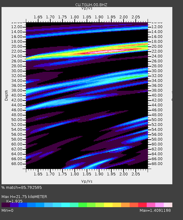
| Estimated Moho Depth: |
21.75 km |
| Estimated Crust Vp/Vs: |
1.93 |
| Assumed Crust Vp: |
6.597 km/s |
| Estimated Crust Vs: |
3.41 km/s |
| Estimated Crust Poisson's Ratio: |
0.32 |
|
| Radial Match: |
85.792595 % |
| Radial Bump: |
400 |
| Transverse Match: |
64.54535 % |
| Transverse Bump: |
400 |
| SOD ConfigId: |
11737051 |
| Insert Time: |
2019-04-27 07:10:23.897 +0000 |
| GWidth: |
2.5 |
| Max Bumps: |
400 |
| Tol: |
0.001 |
|

Signal To Noise
| Channel | StoN | STA | LTA |
| CU:TGUH:00:BHZ:20170508T15:42:58.275026Z | 1.9354931 | 2.8470933E-7 | 1.4709913E-7 |
| CU:TGUH:00:BH1:20170508T15:42:58.275026Z | 1.3973252 | 1.6781166E-7 | 1.2009494E-7 |
| CU:TGUH:00:BH2:20170508T15:42:58.275026Z | 1.0009968 | 1.25428E-7 | 1.253031E-7 |
| Arrivals |
| Ps | 3.2 SECOND |
| PpPs | 9.4 SECOND |
| PsPs/PpSs | 13 SECOND |


