You are here: Home > Network List > US - United States National Seismic Network Stations List
> Station WMOK Wichita Mountains, Oklahoma, USA > Earthquake Result Viewer
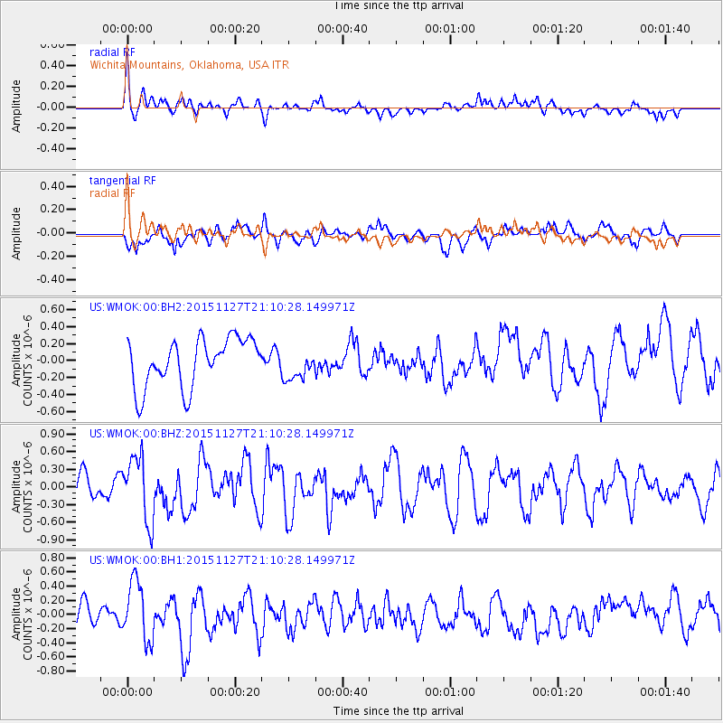
WMOK Wichita Mountains, Oklahoma, USA - Earthquake Result Viewer
*The percent match for this event was below the threshold and hence no stack was calculated.
| Earthquake location: |
Near Coast Of Northern Chile |
| Earthquake latitude/longitude: |
-24.8/-70.6 |
| Earthquake time(UTC): |
2015/11/27 (331) 21:00:22 GMT |
| Earthquake Depth: |
35 km |
| Earthquake Magnitude: |
6.2 MWW, 6.2 MWB |
| Earthquake Catalog/Contributor: |
NEIC PDE/NEIC COMCAT |
|
| Network: |
US United States National Seismic Network |
| Station: |
WMOK Wichita Mountains, Oklahoma, USA |
| Lat/Lon: |
34.74 N/98.78 W |
| Elevation: |
486 m |
|
| Distance: |
65.0 deg |
| Az: |
334.609 deg |
| Baz: |
151.762 deg |
| Ray Param: |
$rayparam |
*The percent match for this event was below the threshold and hence was not used in the summary stack. |
|
| Radial Match: |
54.99507 % |
| Radial Bump: |
400 |
| Transverse Match: |
58.67315 % |
| Transverse Bump: |
400 |
| SOD ConfigId: |
1259291 |
| Insert Time: |
2015-12-11 22:08:44.647 +0000 |
| GWidth: |
2.5 |
| Max Bumps: |
400 |
| Tol: |
0.001 |
|
Signal To Noise
| Channel | StoN | STA | LTA |
| US:WMOK:00:BHZ:20151127T21:10:28.149971Z | 1.8313594 | 5.59015E-7 | 3.0524595E-7 |
| US:WMOK:00:BH1:20151127T21:10:28.149971Z | 1.7775637 | 4.229088E-7 | 2.3791485E-7 |
| US:WMOK:00:BH2:20151127T21:10:28.149971Z | 0.63457775 | 1.7928772E-7 | 2.8253078E-7 |
| Arrivals |
| Ps | |
| PpPs | |
| PsPs/PpSs | |


