You are here: Home > Network List > UU - University of Utah Regional Network Stations List
> Station JLU Jordanelle, UT, USA > Earthquake Result Viewer
JLU Jordanelle, UT, USA - Earthquake Result Viewer
| Earthquake location: |
Near Coast Of Northern Chile |
| Earthquake latitude/longitude: |
-24.8/-70.6 |
| Earthquake time(UTC): |
2015/11/27 (331) 21:00:22 GMT |
| Earthquake Depth: |
35 km |
| Earthquake Magnitude: |
6.2 MWW, 6.2 MWB |
| Earthquake Catalog/Contributor: |
NEIC PDE/NEIC COMCAT |
|
| Network: |
UU University of Utah Regional Network |
| Station: |
JLU Jordanelle, UT, USA |
| Lat/Lon: |
40.60 N/111.45 W |
| Elevation: |
2285 m |
|
| Distance: |
75.3 deg |
| Az: |
329.04 deg |
| Baz: |
142.123 deg |
| Ray Param: |
0.051681288 |
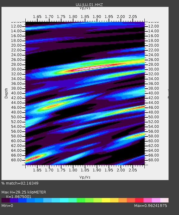
| Estimated Moho Depth: |
29.25 km |
| Estimated Crust Vp/Vs: |
1.87 |
| Assumed Crust Vp: |
6.155 km/s |
| Estimated Crust Vs: |
3.296 km/s |
| Estimated Crust Poisson's Ratio: |
0.30 |
|
| Radial Match: |
82.16349 % |
| Radial Bump: |
400 |
| Transverse Match: |
53.942516 % |
| Transverse Bump: |
400 |
| SOD ConfigId: |
1259291 |
| Insert Time: |
2015-12-11 22:09:48.089 +0000 |
| GWidth: |
2.5 |
| Max Bumps: |
400 |
| Tol: |
0.001 |
|

Signal To Noise
| Channel | StoN | STA | LTA |
| UU:JLU:01:HHZ:20151127T21:11:31.489998Z | 2.5288672 | 1.4191333E-8 | 5.6117355E-9 |
| UU:JLU:01:HHN:20151127T21:11:31.489998Z | 1.1933331 | 7.0296817E-9 | 5.890796E-9 |
| UU:JLU:01:HHE:20151127T21:11:31.489998Z | 0.716318 | 4.30947E-9 | 6.016141E-9 |
| Arrivals |
| Ps | 4.2 SECOND |
| PpPs | 13 SECOND |
| PsPs/PpSs | 17 SECOND |


